We all know that easy access to data speeds up doing research. In this post, we will discuss how open GIS data can stimulate innovative ways of doing research in the field of geodesy and geosciences, considering first the benefits and challenges of open data.
Geodesy can benefit greatly from the open data movement and from open Geographic Information System (GIS) data. The reasons for this are two. First, open data, namely data freely usable, re-usable and re-distributable, promotes transparency, verifiability, encourages interdisciplinary studies, knowledge-exchange, etc. See also “13 Reasons for Open Publication of Geoscience Data”. Second, GIS allows the storage, manipulation, managing and analysis of topographic data. Hence, open GIS data is a powerful tool for geoscientists and geodesists who can conduct data-driven analyses like never before.
Yet, utilising open data in the geodesy field is often easier said than done. A recent Open Knowledge International’s report identified the main problems hindering the open data movement. These are: the very low discoverability of open data sources, which were rightfully defined as “hard or impossible to find”; the lack of interoperability of open data sources, often very difficult to be utilised; and the lack of a standardized open license, representing a legal obstacle to data sharing. These problems thus prevent open GIS data sources from being fully exploited for scientific advancements in geodesy.
Some initiatives have tried to address the problems above. OpenStreetMap, for instance, is a collaborative and voluntary project which utilises satellite data to create maps of the world. The EU launched Copernicus, a programme aimed at developing European information services based on satellite and in-situ data. These initiatives contribute to improve the findability of data, but do not address a crucial problem: how to reutilise GIS data to create applications, spurring innovative ways of conducting scientific research in geodesy. If apps based on GIS data were created and made available to geodesists, they could utilise these tools to conduct data-driven research, visualise topographic sources, collect more data, etc.
Open data aggregators could help address this issue. Aggregators have two main functions: data aggregation and integration. Aggregation consists of creating hubs where multiple data sources can be accessed for various purposes. Integration refers to linked data, namely data to which a semantic label (a name describing a variable) is attached to allow for the integration and amalgamation of different data sources (Mazzetti et al 2015, Hosen and Alfina 2016, Qanbari et al 2015, Knap et al 2012). The integration function is precisely what renders data re-usable.
Below we present an aggregator particularly suited to the resolve the re-utilisation problems hindering GIS data: The European Network for Redistributing Geospatial Information to user Communities- Open Data (ENERGIC-OD). The ENERGIC-OD consortium, funded by the European Commission, launched a pan-European Virtual Hub (pEVH). This is a super-broker that automatically searches for open GIS data available online (i.e. GEOSS, INSPIRE, COPERNICUS data and new/existing, local/national Spatial Data Infrastructures or SDIs ), process it and renders it ready to use for app developers, facilitating open GIS data usage across Europe. The image below shows the pEVH’s brokering framework, including some examples of the datasets processed. The readers can access the pEVH today here.
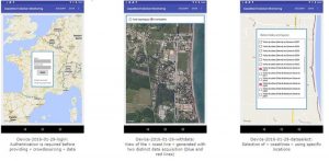
To demonstrate the viability of the pEVH, ENERGIC-OD consortium developed 10 applications based on VH-brokered data. One of these apps, the Coastline Monitoring Application, constitutes an interesting and innovative development in the geoscience research world and provides an idea of what can be achieved with applications based on GIS data.
 This app allows registered users to contribute directly to the study of coastlines, providing scientists and researchers with valuable information and observations. The application utilises the pEVH’s crowdsourcing functionality that allows people to produce data, in the form of images for example, which will be then checked and validated before being shared with the wider public. This app has thus a three-fold function of data generator, validator and sharer.
The Coastline Monitoring Application is just one example of what can be achieved with ENERGIC-OD and what this data broker can do for geosciences and geodesy. The pEVH has the potential to resolve issues of low discoverability, lack of interoperability and low re-usage burdening the open GIS data world. Additionally, thanks to its brokering features, any scientist with basic computer programming skills can extract and manipulate GIS data for app-development. These apps have the potential to be of great usefulness to geodesists. ENERGIC-OD can thus be a great facilitator of geoscience research. It is up to the wider scientific community to exploit its functionalities in innovative and meaningful ways.
References:
Hosen, A. and Alfina, I. (2016). Aggregation of Open Data Information using Linked Data: Case Study Education and Job Vacancy Data in Jakarta. IEEE, pp.579-584.
Knap, T., Michelfeit, J. and Necasky, M. (2012). Linked Open Data Aggregation: Conflict Resolution and Aggregate Quality. IEEE 36th International Conference on Computer Software and Applications Workshops, pp.106-111.
Mazzetti, P., Latre, M., Bauer, M., Brumana, R., Brauman, S. and Nativi, S. (2015). ENERGIC-OD Virtual Hubs: a brokered architecture for facilitating Open Data sharing and use. IEEE eChallenges e-2015 Conference Proceedings, pp.1-11.
Qanbari, S., Rekabsaz, N. and Dustdar, S. (2017). Open Government Data as a Service (GoDaaS): Big Data Platform for Mobile App Developers. IEEE 3rd International Conference on Future Internet of Things and Cloud, pp.398-403.
Edited by Katrin Bentel and Roelof Rietbroek
Authors:
 Giuseppe Maio is a research assistant working on innovation at Trilateral Research. You can contact him at giuseppe.maio@trilateralresearch.com and his twitter handle is @pepmaio
 Jedrzej Czarnota is a research analyst at Trilateral Research. He specialises in innovation management and technology development. You can contact Jedrzej at Jedrzej.czarnota@trilateralresearch.com and his twitter is @jedczar
