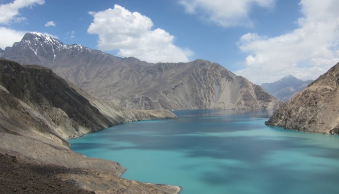
Despite its alluring turquoise waters and rugged mountain backdrop the story behind this beautiful lake is rather more troubling. In today’s Imaggeo on Mondays, the first post since our short break from the traditional format during the General Assembly, Alexander Osadchiev writes about the shaky origins of Sarez Lake.
Lake Sarez is situated in Tajikistan, deep in the Pamir Mountains. In 1911 a local earthquake caused a large landslide which blocked the valley of the relatively small Murgab River (which discharge is only 100-150 m^3/s). The valley is relatively young, on the geological scale at least, meaning it is deep and narrow and has steep sided slopes. This is the reason why the moderate volume of the landslide (about 2 km^3) was enough to form the tremendously high Usoi dam (about 550 m) – the tallest in the world either natural or man-made. The length of the Usoi dam is about 500 m which is almost equal to its height. However, lakes formed by landslide dams blocking river valleys are not uncommon in the Pamir Mountains or elsewhere around the world.
Most blocking dams are not high or solid enough to remain in place for extended periods of time. Initially, a river will seep through the dam eroding it, but usually the outflow discharge is less than the river inflow into the lake. Together with active sedimentation and silting, the water level in the lake steadily increases until it reaches the dam height. Eventually water starts flowing over the top of the dam and intensively destroys the dam. Yet due to a number of circumstances the behavior of the Sarez Lake was significantly different. On the one hand, the Usoi dam is solid enough not to have been significantly eroded in the more than one hundred years since it appeared. At the same time, it is porous: outflow and inflow volumes of water across the dam balance each other. Crucially, this balance was obtained for a very high water level, close to the height of Usoi dam itself. Lake water levels oscillate near 500 m height, just 50m away from the top of the of 550 m dam. The height of the dam resulted in the large size of the Sarez Lake – its length is about 60 km and its volume exceeds 16 km^3.
This large volume of water (and potential energy!) situated high in the mountains (3263 m above the sea level) presents a hazard for millions of people in Tajikistan, Afghanistan, and Uzbekistan living below the Sarez Lake and along the banks of the Mugrab, Panj and Amu Darya rivers. The Usoi dam is solid enough to resist erosion and create such a big lake, but it is not known if it can withstand a big earthquake, which are not uncommon in the area. Not only can an earthquake directly destabilize Usoi dam, but an earthquake-induced landslide into the lake could cause a lake tsunami and result in the dam overflowing. Particularly, an area of friable soil forming a unstable slope, has been particularly identified as a risk. Following a large earthquake (8-9 on the Richter scale) it could presumably form a landslide.
The levels of monitoring and investigation of landslide hazards in the region and the risk presented by Lake Sarez itself are still largely understudied. Limited funding availability in Tajikistan and the remoteness of the lake – it can only be reached on foot, after several days of strenuous mountain trekking through an almost uninhabited, but unbelievably beautiful area – are amongst the main reasons this is so.
“The view of the Sarez Lake was the best prize for me and Zhamal Toktamysova at the final part of our 2-week trekking through the Pamir Mountains”, explains Alexander.
By Alexander Osadchiev, Shirshov Institute of Oceanology, Physical Oceanography, Moscow

Pingback: » What’s up? The Friday links (78)
@eryoljde
M 7,0 and above. Earthquakes we know in advance. There are periods of earthquakes. 24 APRİL 2015 and 25 APRİL 2015 M 7,0 and above will be earthquakes. Geographical location uncertain.