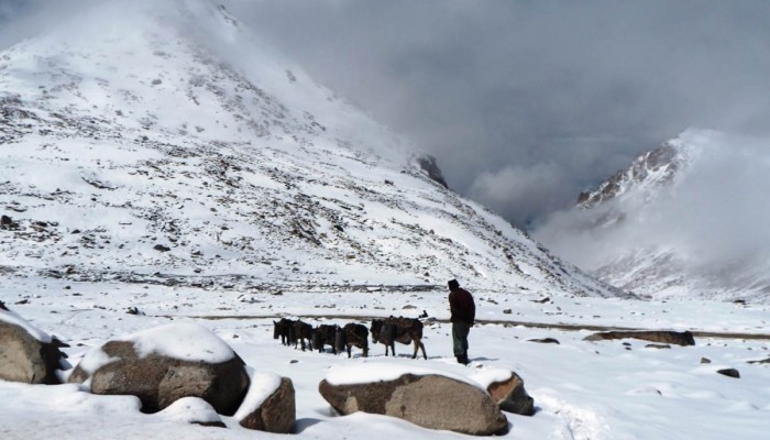
Figure 1: A man herds his livestock in remote, high altitude, snowy conditions in Ladakh.
This post first appeared on GeoEd Trek (AGU Blogs) on December 22nd 2014. It has been slightly modified below, given the deadline for EGU Abstracts has now passed, to include the latest information available about this session.
Ladakh is a remote and beautiful Himalayan region in the north of India (Figure 1). With stunning landscapes and a rich culture and history it is popular with both domestic and international visitors. Ladakh is also a region subjected to multiple natural hazards, including extreme temperatures, avalanches, landslides (Figure 2), earthquakes and unusual heavy rain, each occurring with varying frequency and intensity. One of the worst examples of recent times was in August 2010, when a devastating mudslide impacted Ladakh. The result of sudden and intense rainfall, the mudslide killed over 255 people.

Figure 2: Ladakhi village sitting at the foot of steep hillslopes, a typical scene in Ladakh and an example of the communities’ high exposure to mass movement hazards.
Challenges associated with these natural hazards, together with issues relating to energy, tourism, water supply and environmental change were the focus of a major international conference in the town of Leh in June 2014.‘Sustainable Resource Development in the Himalayas’, a three day event drawing participants from across the Himalayan region and beyond, was organised by the Geological Society of London alongside the University of Jammu. Running before and after this conference was a geoeducation programme, working with students from multiple ethnic and socio-economic backgrounds, exploring topics ranging from the Himalayan glaciers to landslide and earthquake dynamics. The geoeducation aspect of the programme was co-organised by the University of Jammu (Ladakh, India) and Geology for Global Development (GfGD), a UK-based not-for-profit that I established in 2011 (Figure 3). It was delivered in three settings: (i) a large secondary school close to the important town of Leh, with students coming from many surrounding schools; (ii) a medium sized boarding school 200km away from Leh, with many children from nomadic families in the region; and (iii) a small boarding school with many very young children, all coming from nomadic families.

Figure 3: The GfGD and Jammu University team with some of the students at Nyoma Residential School.
Implementing a geoeducation project in an unfamiliar region, both geographically and culturally, brought with it a number of exciting challenges, including the availability (or lack of) of materials and resources, language and cultural differences, managing communications between stakeholders before and after the event, and long-term monitoring and evaluation. These challenges were fantastic learning opportunities for the GfGD team, comprised entirely of undergraduates and postgraduates, and our wider network. Geoscientists often find themselves working overseas, in regions with cultures and systems far removed from what we are used to. Engagement with geoeducation during these opportunities may take many forms – from traditional classroom teaching to informal mentoring and knowledge exchange. Attempting to deliver material designed for a UK-audience (my ‘home’ audience), and in a way suited to a UK-audience, in such settings would not necessarily be successful. Instead, consideration is needed of locally-relevant examples, demonstrations and delivery methods. If we hope to have maximum impact in our education, especially when utilising the fantastic opportunities we have to visit far-flung places, these are factors we should take seriously and be diligent in considering.
Our component of the teaching focused on natural hazards, vulnerability and disasters, with a special emphasis on landslides. Additional exercises relating to earthquake dynamics and mitigation were designed and delivered by theBritish Geological Survey’s School Seismology Project. Our work was underpinned by mini-research projects, undertaken by UK students, about landslides, local geology and culture/demographics. Building on this foundation, we put together course content that was relevant to the students and designed a series of simple, interactive demonstrations. Students used photographs of landslides to look for similarities and differences. They used locally available soil, sand and gravel to create their own landslides and investigate angles of failure, the impact of water, the impact of sediment size and what happens if there is (seismic) shaking (Figure 4). Alongside the technical geoscience, we introduced topics relating to exposure and vulnerability. In the UK, these are sometimes taught in isolation from the engineering geology that relates to slope stability. In the same way that this doesn’t serve UK students well, it wouldn’t serve the students in this landslide-prone region to only give them half the story. Understanding the relationship between vulnerability, exposure and a geophysical hazard, in generating a disaster, was an essential message to communicate. It reinforces that some actions can be taken to minimise the impacts of future disasters.

Figure 4: Rosalie Tostevin (GfGD) leads a landslide simulation practical exercise in Nyoma Residential School.
The delivery of the material went very well. We were delighted to be able to leave short textbooks in each school, together with posters and examples of some of the demonstrations. We also left copies of the teaching material with the Ministry of Education at the Ladakhi Autonomous Hill Development Council. As acknowledged previously, assessing and evaluating the real impact of such a project comes with a number of difficulties. We will, however, continue to work with colleagues at the University of Jammu and associated institutions to follow up this work with the overall aim that educators in the region can replicate and adapt these lessons themselves to use with future students.
Teaching about natural hazards is about more than building an appreciation of geoscience. It has the important purpose of reducing individual, family and even societal vulnerability to future hazard events. Understanding the relationship between earthquakes and tsunamis facilitates rapid evacuation. Helping communities living close to volcanoes better understand the different types of eruption and secondary hazards such as pyroclastic flows and lahars can improve partnerships between local observatories and communities. Strong partnerships mean early warning messages are better understood and acted upon. Finally, understanding slope dynamics can help inform building and agricultural practice decisions. For the young people of Ladakh, helping them to better understand their landscapes can be a powerful tool in their hands (Figure 5).

Figure 5: Joel Gill (GfGD) answers extra questions on slope stability from keen students after his class ends.
Given the importance of the subject, I’m really pleased to be co-convening a session with a number of colleagues from across Europe at the European Geosciences Union General Assembly in Vienna next year. The session, titled Natural Hazards Education, Communications and Science-Policy-Practice Interface, is particularly interested in: (i) The communication (by scientists, engineers, the press, civil protection, government agencies, and a multitude other agencies) of natural hazards risk and uncertainty to the general public and other government officials; (ii) Approaches that address barriers and bridges in the science-policy-practice interface that hinder and support application of hazard-related knowledge; (iii) The teaching of natural hazards to university and lower-level students, using innovative techniques to promote understanding.
We will be linking this session to an opportunity for discussion and a short course on natural hazard teaching demonstrations. If you are planning on attending EGU, come and get involved in these great opportunities to explore the teaching of a topic that is of interest to so many around the world!