EGU Blogs

arctic

Geology Photo of the Week #52 – Looking from the past to the future

This weeks photo is a beautiful yet sad reminder that Arctic research and work is still a dangerous undertaking just as it was for the early Arctic explorers.

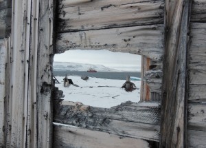
The following text is by Vladislav Petrusvich: Canadian research icebreaker CCGS Amundsen by Beechey Island in 2013 after tragic event when a researcher (Klaus Hocheim), captain and a helicopter pilot were killed in a tragic helicopter crash during scientific cruise. Beechey Island is related to ill-fated Franklin expedition that overwintered at the island. The shot is made through the remaining wall of a supply depot used by the search parties looking for disappeared Franklin expedition in 19th century.

Beechey Island is located in the Northwest Passage and was named after the artist on board Capt. William Perry’s Arctic exploration in 1819. Beechey Island was next visited by the Franklin expedition in 1845 as Sir John Franklin’s first winter encampment aboard the HMS Erebus (discovered in 2014) and Terror (not yet found). Recent archaeological investigations by Parks Canada have found three mummufied bodies that had died of lung disease and lead poisoning, which appeared to be from the lead solder used in the canning of food although it now appears that the lead may be from the water distillation system on the ships.

Geology Photo of the Week #45

This weeks photo is once again related to permafrost and the Arctic….something tells me I miss being there.

Anyway, the gorgeous photo below shows a terrific example of polygonal patterned ground from Siberia. Patterned ground is a phenomenon that occurs frequently in cold regions and is caused by the seasonal freeze-thaw of the active layer/soil. This process can produce a phenomenon called ice wedges that extend deep into the permafrost (see my photo of a large ice wedge below) as water infiltrates into a crack freezing it and expanding it. This repeats annually as the ice cracks due to the extreme cold and is then filled by new meltwater from the active layer, which freezes.

Ice wedges have excellent potential as a climate research tool as they can be very old and preserve the isotopic signature of each new year’s water. In fact, my research group has an MSc. student working on this exact thing.

Sorting of sediments by the freeze thaw of groundwater also creates patterned ground as the process forces larger sediments upward and lets smaller sediment settle eventually creating little piles of rocks on the ground surface. However, in the case of the photo below, which is in a poorly drained peatland, there are likely lots of ice wedges.

Wet Sedge Polygons on Samoylov Island with Stolb Island in the background - Samoylov Island - Lena River Delta - 20.08.2010 - Sebastian Zubrzycki

Wet Sedge Polygons on Samoylov Island with Stolb Island in the background – Samoylov Island – Lena River Delta – 20.08.2010 – Sebastian Zubrzycki

Ice wedge along the Dempster Hwy. in the Yukon.

Partially collapsed ice wedge in cross section along the Dempster Hwy. in the Yukon. (Photo: Matt Herod)

Thaw Slumps of the NWT

I recently across an article that reminded me of my field work days in the early stages of my PhD in the Canadian Arctic at retrogressive thaw slumps. The article discusses the impending catastrophic drainage of a lake when the thin strip of land separating it from a thaw slump fails (see article), which it will inevitably do very soon. The story has now been picked up all across Canada in the context of climate change and permafrost melting. It was nice to see thaw slumps and permafrost in the news so I thought I’d post a few of my own pictures of these slumps from a few years ago that are very nearby the one in the article. Actually, we worked on these same slumps with Dr. Steve Kokelj from the NWT geological survey who is quoted.

Here are few of my own slump pictures from my fieldwork days in the NWT.

IMG_2860

An aerial view of the Charras slump, which is approximately 1 km across and 30m deep at the headwall. (Photo: Matt Herod – 2011)

IMG_2855

An aerial view of one of the smaller slumps. (Photo: Matt Herod – 2011)

IMG_2830

My colleague, Bernard, from the uOttawa geography department headed towards the headwall for an ice sample. (Photo: Matt Herod – 2011)

IMG_2817

A rainy day in the slump. The mudflow becomes really active when the weather is wet. (Photo: Matt Herod – 2011)