EGU Blogs

GeoSphere

Geology Photo of the Week #52 – Looking from the past to the future

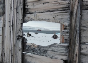
This weeks photo is a beautiful yet sad reminder that Arctic research and work is still a dangerous undertaking just as it was for the early Arctic explorers.

The following text is by Vladislav Petrusvich: Canadian research icebreaker CCGS Amundsen by Beechey Island in 2013 after tragic event when a researcher (Klaus Hocheim), captain and a helicopter pilot were killed in a tragic helicopter crash during scientific cruise. Beechey Island is related to ill-fated Franklin expedition that overwintered at the island. The shot is made through the remaining wall of a supply depot used by the search parties looking for disappeared Franklin expedition in 19th century.

Beechey Island is located in the Northwest Passage and was named after the artist on board Capt. William Perry’s Arctic exploration in 1819. Beechey Island was next visited by the Franklin expedition in 1845 as Sir John Franklin’s first winter encampment aboard the HMS Erebus (discovered in 2014) and Terror (not yet found). Recent archaeological investigations by Parks Canada have found three mummufied bodies that had died of lung disease and lead poisoning, which appeared to be from the lead solder used in the canning of food although it now appears that the lead may be from the water distillation system on the ships.

Photo of the Week #51

I’m getting back in the bog saddle. After a brief hiatus as I was adjusting to the life of a real, productive member of the PGS (post grad school) world I am good to go for blogging again. Enjoy the photo of the week!

8bd50d18505be36c878dd31fd86bd0fd

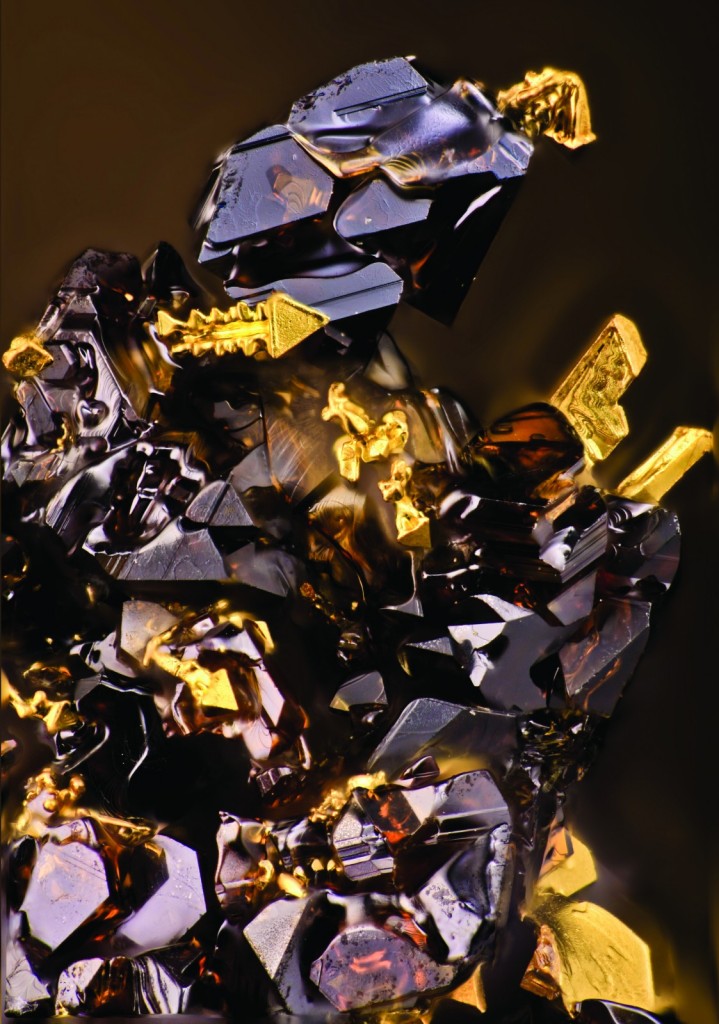
Sphalerite’s “Transformer” by Dmitry Tonkacheev, IGEM RAS, Moscow, Russian Federation

The text that follows is a technical description of the photo by the photographer, Dmitry Tonkacheev.

Presented intergrowths of the infinite number of dark-brown sphalerite’s and arborescent crystals of gold were synthesized using gas transport method at 850 centigrade degree during 20 days by Dmitry Chareev from the Institute of Experimental Mineralogy RAS in Chernogolovka city, Moscow Region while we were working on the project of Russian Scientific Fund in the Institute of Ore Geology, Petrology Mineralogy and Geochemistry RAS.
The main aim of this project was the determination of the maximum possible concentration and chemical state of some trace elements in the most abundant sulfides, synthesized using different techniques, including in ZnS. We obtained crystals of Fe-bearing sphalerite with simultaneous incorporation of Cd, Mn, In, Se and Au. The concentration of gold reaches 3,000 ppm (0.3 wt.%). This is amazing for natural sphalerite. The next goal was in-depth-study of the influence of the presence of Se, In, Fe, Mn on Au concentration and also lattice parameter in ZnS. In this connection in the furnace-charge of Fe-bearing sphalerite, different admixtures were added in different combinations or severally.

According to LA-ICP-MS data Fe did not encourage Au annexation (73±1 ppm). The bulk of Au wire “boards” on the dark-brown phase surface in the form of fascination crystals (usually arborescent). Some of them looks like a weapon from the “Transformers” arsenal or parts of his armor. Also bright diamond luster of this creature makes our “Knight” even more ultra-modern.

Militiamen’s profile was confirmed by twisted skeletal crystal on the transformer’s head. It looks like ostrich plumage or horn, which were the main attribute in the plate armor of ancient warriors and indicated about their noble birth. Truly, it is a king of all sulfides. The good news for us is the fact, that the coarsening of this bellicose subject is approximately 1-2 mm.

GeoPoll: Who do you think most deserves the title “Father of Geology?”

It’s been a while since the last geopoll/post. Too long. Life has been busy for me though. I am just concluding an extremely short post-doc at Health Canada’s Canadian Radiological Monitoring Network and am starting a new job at the Canadian Nuclear Safety Commission next week. Suffice to say blogging has sadly slipped a bit lower on my list than I’d like. Plus it’s hockey and nordic season here in Ottawa.

At any rate, I though it high time to dust off one of my saved up poll ideas. Throughout my geological education the title “Father of Geology” has been bandied about in reference to several different founders of the science. When you google “Father of Geology” James Hutton is featured prominently. But is he really the true “Father of Geology”? I have heard the term applied to many others including: Charles Lyell, Charles Darwin, William Smith and more. Each of these men has made huge contributions to geosciences, but which do you think deserves to be recognized as the sole founder? By the way, when you google “Mother of Geology” you get James Hutton as the top result, sadly.

In no particular order, here are your choices.

James Hutton

Google’s choice for the title but not necessarily yours. James Hutton certainly does deserve a top spot in the “most important contributions to geoscience” power rankings, but just how high is up for discussion. The mind behind the principle of uniformitarianism, which despite its annoying name, is a crucial concept underpinning almost every aspect of geology. Hutton’s theory, simplistically put, states that processes in the present operated in the past. This gave early geologists great insight into the processes that formed the rocks, minerals and fossils they were discovering. It also opened the door to our understanding of geologic time, which is a central tenet of geology and underlies every aspect of the science.

Siccars Point, UK. The place where James Hutton found proof of uniformitariansm in the visible angular unconformity representing the missing time between the two formations. Source

Charles Lyell

Author of the famed text “Principles of Geology” in 1830 is a strong contender for the title without question. Lyell built upon the work of Hutton and greatly furthered the burgeoning science of geology. His key contributions include expanding on Hutton’s concept of uniformitarinism/geologic time as well as dabbling in volcanology, paleontology, and glaciology. He also traveled widely, even to North America where he made observations about geology in the colonies. He was also a friend and colleague of Charles Darwin and is believed to have contributed to the publication of On the Origin of the Species. I should add that many mountains have been named in his honour just in case that little tidbit sways your vote at all.

Charles Darwin

Darwin is without question the “Father of Evolution” but does this also qualify him to be the Father of Geology? Evolution is a central aspect of understanding deep time and how Earth’s biota has changed from the Hadean to now and why. Darwin also worked extensively on paleontology and in addition to On the Origin of the Species wrote several geology books about marine invertebrates, atoll formation by coral reefs and his observations during his travels on the Beagle.

Nicolas Steno

In addition to being the namesake of an entire profession, stenographer (kidding), the contributions Nicolas Steno made to the science of geology cannot be overstated. Especially by sedimentologists. His conception of the laws of superposition, original horizontality, cross relationships and lateral continuity are all central to the ideas of deep time, stratigraphy and how formations relate to one another in the field. Furthermore, his principles inspired the work of Hutton.

An illustration from Steno’s 1669 book Source

Pliny the Elder

Certainly the oldest member of this list, although this doesn’t necessarily mean he’s the most important. As one of the earliest recorded observers of the natural world a few notes about geology made it into his magnum opus, Naturalis Historia in which he discussed Roman mining techniques, prospecting for gold, mineralogy and crystallography, and how to detect a fake gemstone. He also covered geography, astronomy, agriculture, art and medicine. Not too shabby!

Worth an honourable mention is that he actually died in the eruption of Mt. Vesuvius. There is some controversy over how since none of his companions suffered the same fate but he either died trying to rescue some friends trapped near Herculaneum or because he wanted a closer look at Vesuvius and ordered a slave to kill him to avoid cooking to death.

Alfred Wegener

Mr. Jigsaw, Alfred Wegener, deserves to be on the list even though he was not technically a geologist. However, as the recognized originator of the idea of contintental drift he certainly deserves recognition especially now because he was ridiculed for his ideas at the time. It was not really until 1965 when J. Tuzo Wilson developed the supercontinent cycle and other evidence was incorporated that theory of plate tectonics became really proven and Wegener’s ideas fully accepted.

William Smith

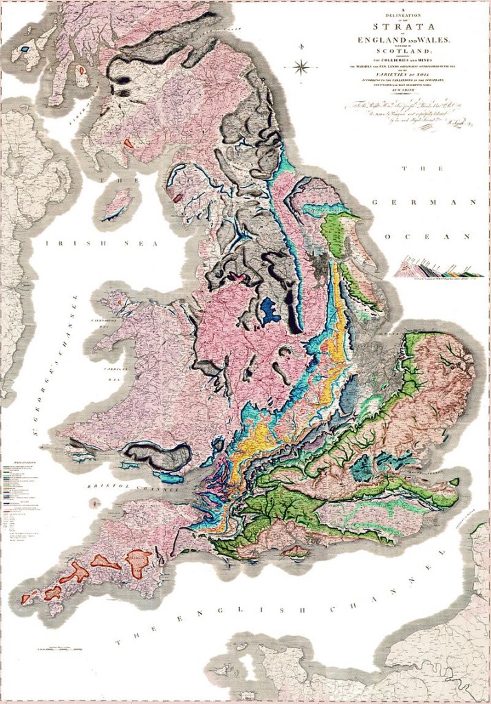
In addition to having the most generic name on the list, William Smith is the originator of the geological map and known as the “Father of English Geology”. However, as geological maps are not the sole province of the UK maybe he gets your vote as the Father of all geology? A canal builder and coal miner, like James Hutton, smith noticed the strata he was digging through repeated predictably throughout England and was the first to map their outcrops. He also originated the idea of faunal succession in rock formations which today is still regularly applied in the concept of relative age dating.

Smith's beautiful map delineating the strata of England and Wales (sorry Scotland) Source

Smith’s beautiful map delineating the strata of England and Wales (sorry Scotland) Source

Mary Horner Lyell

This poll is about the Father of Geology, but here is my vote for the Mother of Geology title: Mary Horner Lyell. Mary Horner Lyell, in addition to being the wife of nominee Charles Lyell was a very accomplished geoscience researcher in her own right and her contributions were critical to the writing and field work of Charles Lyell. They were quite a dynamic duo! She also contributed to Darwin’s work on barnacles and the study of glaciology with fellow female scientist Elizabeth Agassiz.

The assignment of the coveted title of Father of Geology is now in your hands. Choose wisely!

[polldaddy poll=”9276888″]

By the way, feel free to write another name and justification in the comments if you don’t like my options. This is by no means an exhaustive list. I strongly considered adding William Logan and J. Tuzo Wilson to get some Canadian content in there.

Ultimately, it doesn’t matter who the Father of Geology is (sorry voters). As Newton eloquently said, “if I have seen further it is by standing on the shoulders of giants.” This sentiment applies well here as it is irrelevant who really started it all. Rather, it is more important to realize that as the science of geology expands and grows in divergent and convergent directions we are all standing on one another’s shoulders through the sharing of ideas and knowledge. There is no single base to this pyramid just as there is no distinguishable pinnacle.

Tracking the Fallout and Fate of Fukushima Iodine-129 in Rain and Groundwater

A recently published paper (by myself and colleagues from uOttawa and Environment Canada) investigates the environmental fate of the long lived radioisotope of iodine, 129I, which was released by the Fukushima-Daichii Nuclear Accident (FDNA). Within 6 days of the FDNA 129I concentrations in Vancouver precipitation increased 5-15 times above pre-Fukushima concentrations and then rapidly returned to background. The concentrations of 129I reached were never remotely close to being dangerous, however they were sufficient to distinguish the impact of the FDNA on the region.

Subsequent sampling of groundwater revealed slight increases in 129I concentration that were coincident with the expected recharge times. This suggests that a small fraction of the FDNA-derived 129I may have been transported into local groundwater after infiltrating through soils.
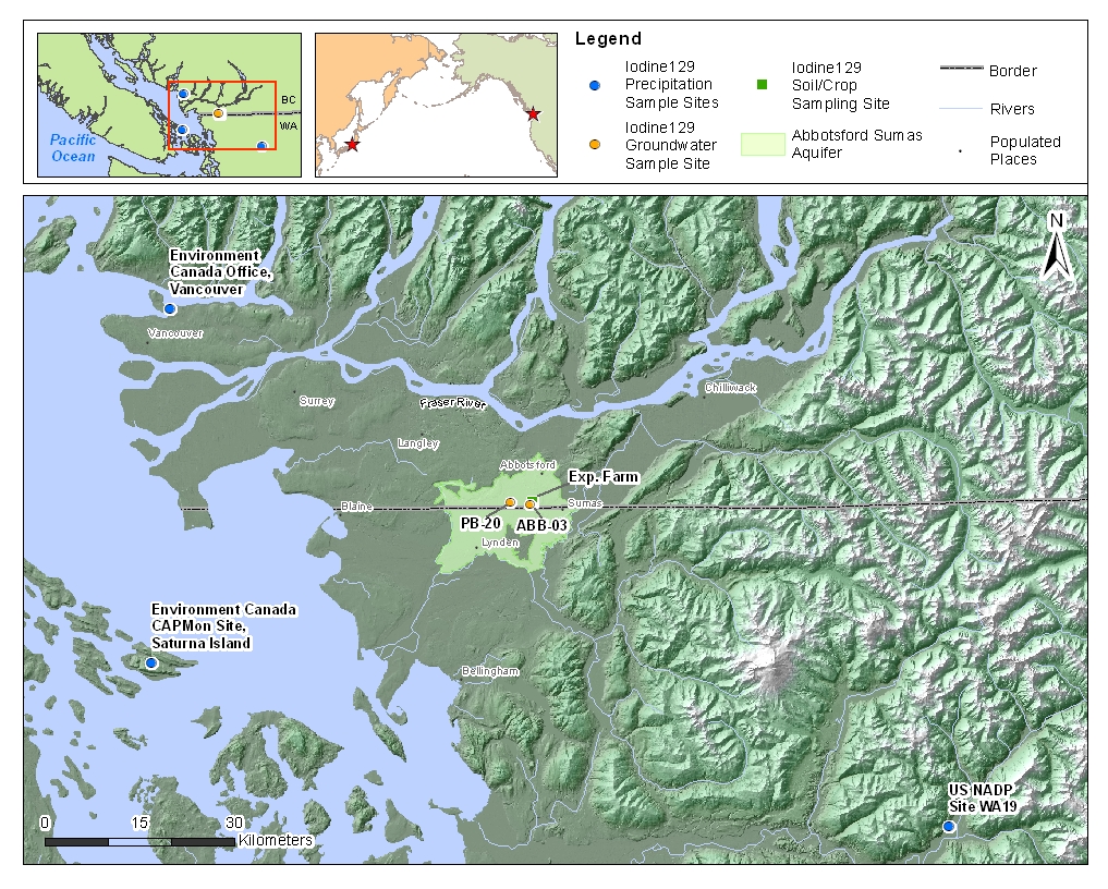
Iodine129_Precip_Sample_BC_JP

Sample map showing location of all three precipitation sampling locations as well as the location of both wells used for groundwater sampling. The surface expression of the Abbotsford-Sumas Aquifer is shaded.

What is iodine-129 and where does it come from?

Iodine-129 is the longest lived isotope of iodine with a half-life of 15.7 million years. It is radioactive and occurs everywhere throughout the environment. It is produced in three ways. The first two are natural and the third is by the nuclear industry.

The natural production of 129I occurs in the atmosphere and in soil/rocks. The atmospheric production happens when a cosmic ray proton hits a xenon-129 nucleus and removes a neutron, replacing it and creating an iodine-129 nucleus. The production in soil and rocks happens when a uranium-238 nucleus spontaneously fissions and one of the halves it releases has a mass of 129 ala, iodine-129.

The anthropogenic production occurs because when uranium fissions in a nuclear reactor sometimes one of the parts is 129I. This anthropogenic production is by far the largest source in the environment as substantial amounts have been released by nuclear fuel reprocessing. This 129I that has been released can trace a host of environmental processes and inform us about what happens to 129I or the much more dangerous, 131I. The current levels of 129I are much too low to pose a health threat to humans or the environment, but do allow 129I to be used as an environmental tracer.

129I from Fukushima is present in Vancouver, B.C. rain

The purpose of this research was to discover the fate of 129I in the released by Fukushima, which although a small amount, was isolated in time and space. We measured the 129I deposition in rain and its subsequent movement though soils and see if it reached groundwater. The results tell us about the impact of Fukushima, how 129I moves, where it is attenuated, and how quickly contaminants in this aquifer move from the ground surface to the water table. This knowledge can then be applied to understand 129I behavior in other settings such as nuclear waste repositories and watersheds or it can be used to learn about the behavior of other types of contaminant in this aquifer and how vulnerable it is to contamination.

The results in rain show an increase in 129I concentrations of up to 220 million atoms/L*. This increase was seen ~6-10 days after the emission from Fukushima began and are 5-15 times higher than rain samples collected before Fukushima. Following this increase 129I concentrations returned to background with a few weeks. This agrees with other studies monitoring the fallout of Fukushima derived radioisotopes [Wetherbee et al., 2012]. Furthermore, atmospheric back trajectory modelling shows trajectories for air parcels arriving in Vancouver from over the Pacific ocean and Japan.
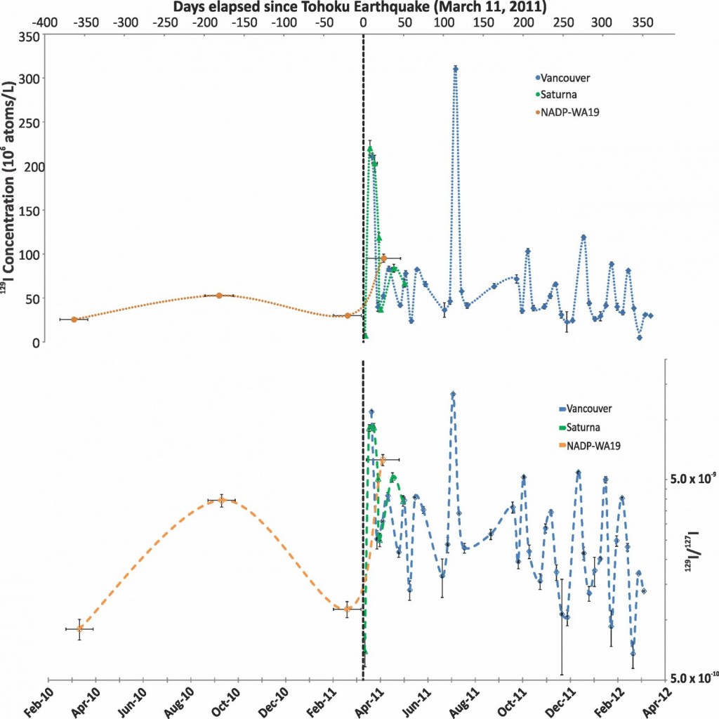
Figure2_129IPrecip

Variation in the concentration of 129I and the 129I/127I ratio in precipitation from Vancouver, Saturna Island and NADP site WA19 over time. The time range that each NADP sample integrates is displayed using horizontal error bars. 1σ error is contained within data points if not visible. The dashed vertical line shows the date of the FDNA relative to samples.

We also calculated the mass flux of 129I from Fukushima. That is the actual quantity of 129I that was deposited on the region in grams, or in this case in atoms/m2. This was calculated by simply multiplying the concentration of 129I in rain by the amount of rain that fell. We found that only about 15% of the annual 129I deposition in the Vancouver region could be directly linked to Fukushima affected rain events. The total mass deposited by Fukushima was ~0.0000000000002 (2 x 10^-13) grams. This is a negligibly small quantity with respect to radioactive risk.

Despite the fact that the deposition of 129I from Fukushima was infinitesimally small it was still measurable. Therefore, the question became where did it go and can we learn about local groundwater resources using 129I as a tracer?

129I variation in groundwater may be due to Fukushima

The results in groundwater show very small 129I concentration increases. Two different wells were sampled. The first had a recharge time, which is the time it takes for water to move from the water table to the well screen, where it is sampled, of 0.9 years and the second had a recharge time of 1.2 years [Wassenaar et al., 2006]. The exact time it takes for water and dissolved contaminants to travel through the unsaturated zone was unknown. However, the sediments of this aquifer are very coarse and are known for their ability to rapidly transport contaminants, such as nitrate [Chesnaux and Allen, 2007]. Therefore, if we were going to see 129I from Fukushima this was an ideal location.

The increases in groundwater 129I concentrations were seen in two different wells (ABB03 and PB20) located close to one another. The two wells also had slightly different recharge times. The first was 0.9 years and the second was 1.2 years. The 129I anomaly in the first well occurred at 0.9 years and in the second well at 1.2 years. These 129I anomalies, which occurred exactly when the recharge age predicted they would, suggests that some of the 129I deposited by Fukushima was reaching the wells and causing these increases.
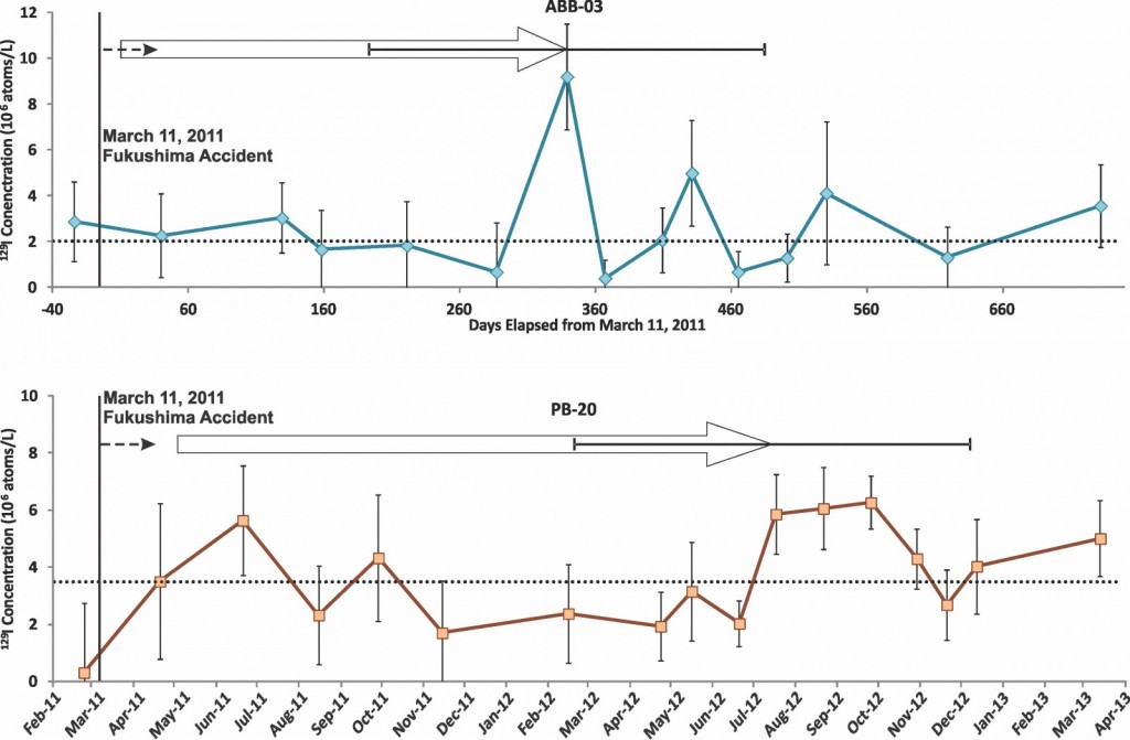
Gwater_129Iconc

Temporal variation in the concentration of 129I in groundwater in ABB03 and PB20. The solid vertical line shows the date of the Fukushima accident and the dashed horizontal line shows the median of each dataset respectively. The 3H/3He ages from [Wassenaar et al., 2006] of groundwater in each well and their uncertainty is pictured as the solid arrow which is aligned with the 129I anomaly possibly caused by the FDNA. The dashed arrow covers a 40 day (0.11 year) time span and represents a possible vadose zone transport time.

In order to verify if it was possible for 129I to travel from the ground surface to the water table in the time required to produce the variations observed we modelled its transport time and attenuation through the unsaturated zone.

The time it took for 129I to reach the water table in the model was then added to the previously dated recharge time to get an estimate for how long it might take 129I from Fukushima to reach the wells we sampled. The results show that it is indeed possible for 129I deposited in rain to infiltrate through the unsaturated zone and reach the wells in time for us to detect it. However, this rapid transport assumes that certain flow paths exist to rapidly conduct 129I due to the heterogeneous lithology of the unsaturated zone. There is evidence of such flow paths [McArthur et al., 2010].

To summarize,


  • Within a week of the FDNPP accident elevated 129I concentrations were observed in precipitation. This agrees very well with work on other radionuclides in air filters and rain.
  • 129I concentrations in rain returned to background within a few weeks. However, discrete pulses of elevated 129I occurred for another several months.
  • Elevated 129I concentrations were measured in two wells and corresponded with the expected recharge times indicating that 129I from Fukushima can be traced into groundwater.
  • Vadose zone modeling has shown that 129I can be rapidly transported to the water table and reach the well screen in accordance with groundwater ages.
  • We propose 129I transport is enhanced by preferential dispersion of 129I that exists due to the heterogeneous nature of the vadose zone.
  • This results in variability in groundwater 129I concentrations that preserve the variability in the input of 129I via washout with some dampening of the signal due to attenuation and dilution.
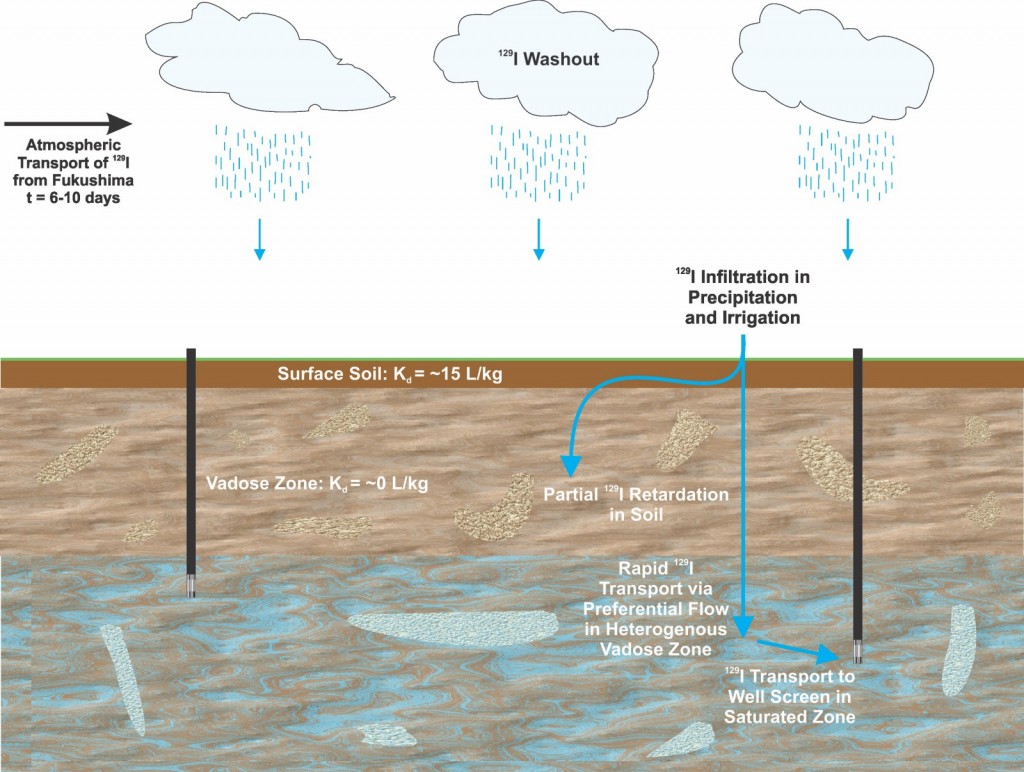


Fukushima Model

Conceptual model showing the possible transport pathways of Fukushima derived 129I which was deposited via precipitation. A fraction of this 129I was rapidly transported through a heterogeneous vadose zone via preferential flowpaths to groundwater where minor 129I variation was detected. The remainder was retarded or attenuated in the vadose zone during transport.


Thanks for reading, if you have any questions or concerns please leave a comment or send me an email to discuss further!

*Note: 100 million atoms/L of 129I is equivalent to an activity of 0.00000014 (1.4 x 10^-7) Bq/L. These quantities are extremely low level and only the most sensitive analytical methods in the world can detect them. This amount of radioactivity is several orders of magnitude lower than the natural background radiation produced by naturally occurring radionuclides in soil and the atmosphere. For more on naturally occurring radioactivity see here. Even a clean rainfall has about 1 Bq/L of tritium (radioactive hydrogen), which remains from atmospheric weapons testing in the 1960’s

Access the full paper here: http://onlinelibrary.wiley.com/doi/10.1002/2015WR017325/abstract

References

Chesnaux, R., and D. M. Allen (2007), Simulating Nitrate Leaching Profiles in a Highly Permeable Vadose Zone, Environ. Model. Assess., 13(4), 527–539, doi:10.1007/s10666-007-9116-4.

McArthur, S. A. Q., D. M. Allen, and R. D. Luzitano (2010), Resolving scales of aquifer heterogeneity using ground penetrating radar and borehole geophysical logging, Environ. Earth Sci., 63(3), 581–593, doi:10.1007/s12665-010-0726-9.

Wassenaar, L. I., M. J. Hendry, and N. Harrington (2006), Decadal geochemical and isotopic trends for nitrate in a transboundary aquifer and implications for agricultural beneficial management practices., Environ. Sci. Technol., 40(15), 4626–32.

Wetherbee, G. A., D. A. Gay, T. M. Debey, C. M. B. Lehmann, and M. A. Nilles (2012), Wet Deposition of Fission-Product Isotopes to North America from the Fukushima Dai-ichi Incident, March 2011, Environ. Sci. Technol., 46(5), 2574–2582.