EGU Blogs

GeoSphere

Back to Basics on Groundwater

Back to Basics on Groundwater

When many people hear the word groundwater they imagine a raging underground torrent of water flowing along a pathway called an aquifer. Well, sorry to disappoint you, but you could not be more wrong about how groundwater exists and flows. In this post we will discuss the very basics of groundwater science (hydrogeology) and flow.

What is groundwater?
As the name implies groundwater is simply water that exists underground. It is the opposite of surface water, which exists on the surface of the Earth such as lakes, rivers and oceans. Groundwater is an extremely important resource for industry, drinking water and other applications, however, it is generally quite poorly understood. The branch of geology that researches groundwater is called hydrogeology and is still a relatively new sector of the geological sciences.

As I have already mentioned groundwater exists underground. However, there are still lots of misconceptions about how people envision groundwater. Many see large underground lakes and rivers, and while those do exist, they represent an infinitesimally small percentage of all groundwater. Generally speaking groundwater exists in the pore spaces between grains of soil and rocks. Imagine a water filled sponge. All of the holes in that sponge are water-filled. By squeezing that sponge we force the water out, similarly, by pumping an aquifer we force the water out of pore spaces.

Notice that SpongeBob is full of pore spaces…I’m not sure if they are water-filled though. (Source: Wikipedia)

There are lots of terms in hydrogeology, most of which are very simple, but essential. Here are a few of the big ones and their meanings.

Porosity: Porosity is an intrinsic property of every material. It refers to the amount of empty space within a given material. In a soil or rock the porosity (empty space) exists between the grains of minerals. In a material like gravel the grains are large and there is lots of empty space between them since they don’t fit together very well. However, in a material like a gravel, sand and clay mixture the porosity is much less as the smaller grains fill the spaces. The amount of water a material can hold is directly related to the porosity since water will try and fill the empty spaces in a material. We measure porosity by the percentage of empty space that exists within a particular porous media.

File:Well sorted vs poorly sorted porosity.svg

Porosity in two different media. The image on the left is analagous to gravel whereas on the right smaller particles are filling some of the pores and displacing water. Therefore, the water content of the material on the right is less. (Source: Wikipedia)

Permeability: Permeability is another intrinsic property of all materials and is closely related to porosity. Permeability refers to how connected pore spaces are to one another. If the material has high permeability than pore spaces are connected to one another allowing water to flow from one to another, however, if there is low permeability then the pore spaces are isolated and water is trapped within them. For example, in a gravel all of the pores well connected one another allowing water to flow through it, however, in a clay most of the pore spaces are blocked, meaning water cannot flow through it easily.

Video showing how connected pores have high permeability and can transport water easily. Note that some pores are isolated and cannot transport water trapped within them. (Source)

Aquifer: An aquifer is a term for a type of soil or rock that can hold and transfer water that is completely saturated with water. That means that all it is simply a layer of soil or rock that has a reasonably high porosity and permeability that allows it to contain water and transfer it from pore to pore relatively quickly and all of the pore spaces are filled with water. Good examples of aquifers are glacial till or sandy soils which have both high porosity and high permeability. Aquifers allows us to recover groundwater by pumping quickly and easily. However, overpumping can easily reduce the amount of water in an aquifer and cause it to dry up. Aquifers are replenished when surface water infiltrates through the ground and refills the pore spaces in the aquifer. This process is called recharge. It is especially important to ensure that recharge is clean and uncontaminated or the entire aquifer could become polluted. There are two main types of aquifer. An unconfined aquifer is one that does not have an aquitard above it but usually does below it. The other type is a confined aquifer that has an aquitard above and below it.
Aquitard: An aquitard is basically the opposite of an aquifer with one key exception. Aquitards have very low permeability and do not transfer water well at all. In fact, in the ground they often act as a barrier to water flow and separate two aquifers. The one key exception is that aquitards can have high porosity and hold lots of water however, due to the their low permeability they are unable to transmit it from pore to  pore and therefore water cannot flow within an aquitard very well. A good example of an aquitard is a layer of clay. Clay often has high porosity but almost no permeability meaning it is essentially a barrier which water cannot flow through and the water within it is trapped. However, there is still limited water flow within aquitards due to other processes that I won’t get into now.
File:Aquifer en.svg
Water Table: The water table is a term that hydrogeologists use to describe an imaginary surface that usually exists underground. Below the water table all pore spaces are completely filled with water and above it they are filled with air. The water table is the boundary between these two zones called the saturated and unsaturated (vadose) zone. In order to imagine the water table it helps to imagine a layer that exists underground rather than a line as the water table is a surface that extends in every direction. The top of the water table is determined by water pressure. When water pressure in the pore spaces is the same as air pressure we are at the water table. The water table is subject to rise and fall depending on pumping of water out of the aquifer or other changes. Finally, if the water table and the surface of the Earth intersect we have a spring.
File:Water table.svg

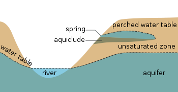
Cross section of what the water table looks like as a line. Remember it is actually a surface that extends in every direction. Note that the water in the well only rises to the surface of the water table because air pressure and water pressure are equal at the water table. (Source: Wikipedia) 

Groundwater Flow

The study of hydrogeology is a very mathy one. There are lots of complicated equations, Greek letters, and funny squiggles. However, you don’t need an advanced degree in math to understand the basics, but it helps to know a little bit. Basically all ground water flow can be described by a single simple equation. Sure, there have been lots of modifications made to fit specific conditions and circumstances, but it all comes back to the same basic principles outlined in a single equation. That equation is called Darcy’s Law (cue dramatic music).

Henry Darcy – “The father of hydrogeology”

Darcy’s law states that the velocity water flows is dependant on the material which it flows through and the hydraulic gradient, which is the difference in water level between two points of measurement divided by the distance between them. In mathematical terms it looks like this:

Darcy’s Law

Q is the discharge or the amount of water that flows out of a given material over a set amount of time.

K is called the hydraulic conductivity and is a property of every material that tells us the speed any liquid moves through a given material. It is directly related to the porosity and permeability of the the material and the density of the liquid in question. For water we don’t need to worry about the density though, just the porosity and permeability.
(h1-h2)/l is usually represented by the letter i and is called the hydraulic gradient. It is the difference in water level between the two points of measurement divided by the distance between them.
Here is a graphical representation of the properties that make up Darcy’s law:

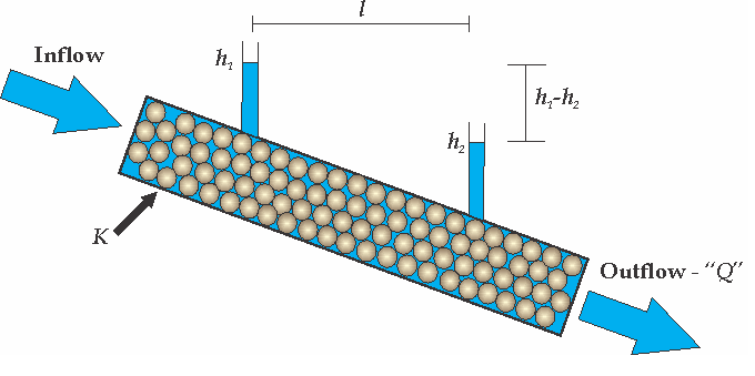
Graphical representation of Darcy’s Law in a hypothetical porous medium with two points of measurement (h1 and h2) and a hydraulic conductivity of K. (Matt Herod – 2011)

So now we understand some of the basic principles governing groundwater flow, but we haven’t discussed why it would flow from one place to another. We all take it for granted that groundwater is not stationary and moves, but why is that? The answer is shockingly simple, and lies in the fact that everything in nature is in a constant struggle to find balance.

Water flows from areas of high energy to low energy in an attempt to distribute that energy evenly throughout the water table. In this case energy is not a synonym for electricity, but energy in all forms, such as pressure or concentration differences. In the case of the water table the driving force is usually differences in pressure and elevation along the surface of the water table which lead to water flow. In hydrogeological terms these energy differences are referred to as hydraulic head, which can be measured at any point in the water table. It is helpful to imagine the weather when we think of groundwater flow. We all know that wind moves from areas of high air pressure to low air pressure bringing weather changes and temperature fronts in with it. Groundwater behaves the same and moves from places with high hydraulic head to low hydraulic head the same as the wind.

Obviously there is much more to discuss in the field of hydrogeology. The big topics being this like contamination or freshwater resources. However, in order to discuss those topics properly it is crucial to have a solid grasp on groundwater terms and basics. Please feel free to to comment if you have any suggestions for future posts on groundwater. Thanks for reading.

Matt

Note: This is a re-post from my old, less visited geo-blog. It was previously posted on June 13, 2011.

The Accretionary Wedge #60 – Call for Posts – Momentous Discoveries in Geology

I am lucky enough to play host to the 60th edition of the Accretionary Wedge. First, I’d just like to highlight the fact that there have been 60 previous and excellent wedges and ! WOW.  This has to be one of the best blog carnivals out there, and here is to another 60 great AW’s in the future.

There are lots of sayings out there about how science is a journey with many steps and paths or a giant building made of many small blocks that contribute to the enormity of an entire field. All of these cliches are pretty much pointing out the same thing. Namely, that the knowledge base in each field is composed of the work of thousands of people all contributing a little bit and slowly building an understanding of the natural world. This is very true, however, some of these contributions are bigger than others, and geology is no exception. Over the history of geology there have been many major discoveries that advanced the science, from the original work of Hutton, Lyell, Steno and Darwin, to more modern revelations. Each discovery has in some way altered our perception of how the Earth works and either opened new avenues of research or provided previously unknown constraints and laws. Therefore, for this wedge the topic will be momentous discoveries in geology or its sub-disciplines that you feel have altered or shaped our understanding of how the Earth works, or opened new doors into research that had never been considered before. The discovery you choose does not have to be universally recognized as momentous but should be in your opinion. It could be something that we take for granted every day, but is in actuality part of the underpinnings of our science.

A tool that changed the world. The telescope of Galileo. I just saw it in Florence along with his middle finger!

The due date for this wedge will be on September 30 and, as usual, add a link to your post in the comments below. I’ll then compile them into a summary post.

Happy discovering,

Matt

Day 3 and 4 – Craters, Very Old Rocks, Fukushima and Extinctions

Here is my Goldschmidt summary part 3 comprising both day 3 and day 4. I had to prepare my own talk, that I gave on Thursday (day 4) so I had to put the blog on hold to practice.

Here are a few of the most interesting talks that I went to:

Fred Jourdan hailing all the way from Curtin University in South Australia gave a talk called  – Volcanoes, asteroid impacts and mass extinctions (abstract). In his funny and very interesting talk Dr. Jourdan asked the question what is responsible for mass extinctions in geologic history? There has always been considerable debate in the scientific community about what caused all of the mass extinctions that have taken place over geologic time. Was it the volcanoes or the meteorite impacts? Dr. Jourdan compared the dates mass extinctions and tied these to the dates of volcanic eruptions and meteorite impacts to see if any two or three occurred at the same time. He found that volcanic eruptions coincided with mass extinctions better than meteorite impacts and concluded that volcanoes have played a dominant role in mass extinctions throughout Earth history. However, meteorite impact dating needs to improve since they also play some role.

Dr. Phillippe Van Cappellen  from the University of Waterloo gave a fantastic keynote address (abstract) on the mysterious part of the groundwater world called the hyporheic zone. The hyporheic zone is the magical place in a stream bed where groundwater flows into the stream. Sounds pretty simple right? According to Dr. Van Cappellen, wrong! Very wrong. It turns out that the hyporheic zone is extremely complicated and can have major impacts on the flow of chemicals from groundwater into surface water. Imagine this scenario: a local aquifer is contaminated with PCB’s. This is bad, but they have not made it into the nearby stream yet, so we only have to remediate groundwater. However, these chemicals will get stored or released by the hyporheic zone and could potentially contaminate a larger area than we thought. Dr. Van Cappellen’s work aims to understand how the h-zone functions under different chemical conditions and what sort of environmental factors such as water level, organic content or freeze-thaw cycles can affect it.

John O’Neill a new professor from uOttawa gave a terrific talk called Earth’s Hadean Crust: Insights from the Nuvvuagittuq Greenstone Belt about some really, really, really old rocks (abstract). In fact he has dated some rocks located in Northern Quebec at 4.4 billion years old!!!! The Earth is only 4.6 billion years old so these rocks have been around right since the beginning. John’s talk was very well attended and he presented some very interesting results to prove that these rocks are so old. This is still a very controversial topic and I am sure that discussions will continue for quite a while.

The next talk was very interesting to me. Dr. Yasuyuki Muramatsu, one of the leaders in the field of radio-iodine research, presented his talk right before mine. His talk was called: Reconstruction of the Accident-Derived I-131 Deposition in Fukushima Through the Analysis of I-129 in Soil (abstract). A lot of iodine-131 was released from Fukushima, which as a short half life of 8 days. This meant that it was very difficult for researchers to map its fallout over Japan, which is essential. However, using iodine-129 as a proxy for iodine-131 is possible and Muramatu’s group set out to do just that and they produced some really nice maps showing the fallout pattern of iodine in Japan.

So that is it for Day 3 and 4. Instead of doing a Day 5 summary I am going to try and do an interview with someone and cover their research in a bit more detail. So stay tuned for that!

Cheers,

Matt

Goldschmidt2013

Goldschmidt 2013 – Day 2 – Carbon, Uranium, Litigation and London

Day 2 of Goldschmidt 2013 is done and what a great day it was. Hectic, but conferences always are. There is just so much to see and do, so many people to talk to and so many people to meet for the first time that it can be a bit overwhelming. The best thing to do is grab a coffee, and dive right in.

My first talk of the day was by J. Schmitt and was called CF4 and CO2 – Coupling Weathering and Carbon Cycle. This very interesting talk introduced me to a new gas that can be used as proxy for weathering over time: CF4. CF4, it turns out, comes from fluorite that is contained in very small quantities in granite. When glaciers scrape the top off a granite outcrop they expose this fluorite and it weathers to release CF4. The CF4 then hangs out in the atmosphere for 50-400 thousand years. It eventually gets trapped in ice cores and can then be used to calculate long term weathering rates.

One thing that everyone does a conferences like Goldschmidt is support their colleagues from home. With this in mind the next talk I attended was by Mike Power from uOttawa. Mike gave a great talk on exploration geochemistry and how we can use noble gases and metals in soil to look for deeply buried uranium deposits.  I won’t go into more detail here. If you want to read about Mike’s work check out the guest post he did for me a few months ago.

Once Mike finished his talk I went to support another familiar face. Not that he needs it since his talk was standing room only. I speak of Dr. Kurt Kyser who hails from my beloved alma mater Queens University at Kingston. Kurt was speaking about the importance of geochemistry to our lifestyles (abstract). Amazingly, Kurt stated that in our lifetimes we each use approximately 2 million kilograms!! of metal, mineral and fuel resources. In order to sustain this quality of life we are always searching for new mineral deposits that can provide us with these things. However, most of the easily obtainable ores deposits have already been obtained. This leaves us with the problem of finding new deposits that are not so easy to discover. Kurt gave a great overview of the techniques we can use to do this, such as sampling unusual things like tree sap or leaves to find deposits. He also made the point that a good geochemical characterization of ore deposits makes remediation much easier when it is time to close the mine and reclaim the land. Yeah Queens!!

The next talk was an interesting look at the source of iodine and chromium in the Atacama desert. It was given by A. Perez-Fodich and was called The role of groundwater in the formation of the giant nitrate deposits of Atacama: Iodine-129 and stable chromium isotopic evidence (abstract). The Atacama desert is one of the dryest places on Earth and is home to some very unusual mineral deposits. Indeed, it is one of the only places on Earth where minable quantities of iodine can be found. The iodine is found in huge nitrate deposits and is likely coming from weathering of nearby ocean sediments. It is then transported by groundwater to the desert where the water evaporates leaving the iodine behind.

The next talk I am going to highlight really galvanized me. I intend to write a full post about this once I get a chance to do some more research. The speaker was Luigi Marini and the talk was called How to Protect Geochemists Working on Environmental Issues from Litigation? (abstract). The talk covered an ongoing Italian court case in which several geochemists from the University of Siena have been sued after publishing results stating that they could not find above background levels of depleted uranium and former Italian military firing ranges. These results infuriated the public which felt that some sort of cover-up was occurring and a local prosecutor initiated litigation against the researchers. This incident has strong shades of the L’Aquila earthquake verdict and therefore it is crucial that strong technical advice is provided by the scientific community to ensure the no miscarriage of justice like that of L’Aquila can happen in this case.

John Ludden, Director of the British Geological Survey, gave a great closing talk in the Importance of Geochemistry session entitled the Geochemistry of London (abstract). At first, I wasn’t sure what to expect. I mean, what geochemistry is there in a city. Wow, was I ever wrong. John introduced the projects that the BGS and partners have going on to monitor and understand pollution in London. This is massive undertaking and they have actually mapped the geochemical distribution of many contaminants on a street by street resolution for the entire city as well as numerous analyses of the water and sediment in the Thames. The most interesting points were the numerous indications of pollution from the past still present in soil and sediment. Indeed, the Thames had very high PAH levels that were left over from the coal burning era and leaded gasoline er, petrol left its mark on London soils. Incredibly, there was one place, the site of a former manufacturing plant, that had such high nickel it could be considered valuable ore material by today’s standards.

Stay tuned for Day 3!

Cheers,

Matt

Goldschmidt2013