During the summer I took part in a fantastic public engagement activity, I’m a Scientist, Get me Out of Here! It’s an X-factor style competition where school students get to meet and interact with scientists. The students are the judges and vote for their favourite scientist to win a cash prize to communicate their work with the public. Sadly, I didn’t win the cash prize, but during the competition, I had to tell the school children what I wanted to do with the cash, should I win. I decided I wanted to donate some of the money to an organisation that raised the awareness of natural hazards in vulnerable communities. I got in touch with Geology for Global Development founder, Joel Gill and asked him if he might be able to point me in the direction of an organisation I might be able to collaborate with.
That’s how I came across Solmaz Mohadjer, founder of ParsQuake: an organisation that works towards promoting earthquake education amongst Persian communities. High strain rates accumulate in the Central Asian region, where the Indian and Eurasian Plate collide. Communities in this region are poorly prepared when it comes to how to protect them selves if a large earthquake were to occur. PasQuake works towards educating the communities that live in the area by raising peoples’ knowledge about natural phenomena as a step towards risk reduction.
Vital Statistics
- You are: Solmaz Mohadjer
- You work at: University of Tübingen
- Your role is: First year PhD student
Q1) What are you currently working on?
I am currently learning to process and examine high resolution remote-sensing imagery from the Pamir region to more accurately locate, map, and categorize previously recognized (but poorly located) faults that are believed to be active.
Q2) What is a typical day like for you?
The truth is that often there is no typical day, and that’s probably a good thing. I try to start my day with a yoga and meditation session, and then treat myself to a good breakfast that can fuel my body and brain for the following activities (listed in no particular order): get the hang of the complicated (or awful as Mark Twain explains) German language, learning about the dynamics of tectonic and surface processes by attending courses at no charge (the awesomeness of attending a German university), obtaining, processing and examining satellite-imagery, looking for geomorphic markers, and discussing them with colleagues. I try to read a lot and learn at least one thing worth learning every day.
Q3) Could you provide a brief insight into the main findings of your research?
My colleagues and I have published a number of papers. Our most recent paper highlights GPS velocity measurements from the Pamir and Hindu Kush regions. These measurements are used to place bounds on present-day slip rates of several major faults and larger scale deformation. This information is useful for identifying or better quantifying regions of high strain with potential for large earthquakes. Other equally important outputs include communication of research results with those who need them the most. We have developed and implemented geohazards training workshops and seminars for school communities and various disaster risk reduction organizations working in the region.
Q4) What has been the highlight of your career so far?
My interest in studying natural hazards goes back to two events: flying over Mount Augustine to measure sulphur dioxide emitted from the volcano a week before it erupted, and backpacking in the Jammu and Kashmir region of India talking to Tibetan refugees about regional earthquake hazards a few days before the devastating 2005 Kashmir earthquake. I became motivated to study natural hazards and to share what I learn with at-risk communities. In 2011, I founded ParsQuake (www.parsquake.org) with a mission to raise levels of earthquake awareness, education, and preparedness of at-risk communities worldwide.

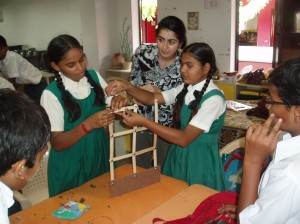
Solmaz during a public engagement activity at a school in Gujarat, India. School children are taught to build and test a wall model on a shake table as part of an earthquake education workshop.
Image courtesy of Solmaz Mohadjer.
Q5) To what locations has your research taken you and why?
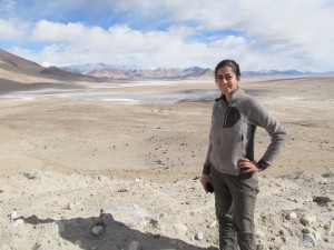
Since the start of my PhD program (May 2013), I have visited the Lauterbrunnen valley in Switzerland to assist with operating a Light Detection and Ranging (LiDAR) laser scanner for collecting data that could help with locating and monitoring rock falls as well as understanding some of the triggering mechanisms. Prior to my PhD program, I worked as a geologist and a geohazard educator for various governmental and non-governmental organizations including humanitarian agencies in China, Afghanistan, Tajikistan, India, and Haiti.
Q6) Do you have one piece of advice for anyone wanting to have a career similar to yours?
Share your scientific data openly, freely, and creatively. One way to do this is to connect with organizations that can help you disseminate your findings with appropriate users in effective ways.
Q7) If you could invent an element, what would it be called and what would it do?
Contentium – A highly stable element that makes people more content and less bitter regardless of their circumstances.
Solmaz is a PhD student at the University of Tübingen in Germany where she applies remote sensing techniques to study the neotectonics and geodynamics of intracontinental mountain systems of Central Asia. Her research interests include tectonics, crustal deformation, and quantification of mountain hazards. In addition to her research, she conducts geohazards education courses and professional development workshops for K-12 school communities and governmental and non-governmental organizations around the world to reduce disaster risk and increase resilience to natural hazards.

