After all the thunderous weather this weekend and being British, I thought I’d do a weather themed science snap. Don’t bolt yet; it’s a volcanic-weather themed!
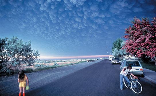
Volcanic mammatus clouds forming after the eruption at Mount St. Helens. Copyright: Douglass Miller
This is a picture of mammatus clouds following the eruption of Mount St. Helens in 1980. These clouds are pretty rare, unusual and distinctive. Formally, the Glossary of Meteorology defines mammatus clouds as “hanging protuberances, like pouches, on the undersurface of a cloud”. The definition is aptly descriptive, but in essence mammatus are a series of bulges at the base of clouds, often under large thunderous cumulonimbus clouds. There are many different types of mammatus clouds, each with distinct properties and occurring under various cloud types, and mammatus in volcanic clouds is just one subcategory. There are relatively few documented occurrences of Mammatus under volcanic clouds. Apart from Mount St. Helen’s, they’ve been observed at during the eruption of Mount St. Augustine on 27–31 March 1986 and Mount Redoubt on 21 April 1990. No generally accepted formation for these mechanism exists, however it is clear that a sharp temperature gradient and a wind shear across the cloud-air boundary is needed to create these clouds. Did anyone spot Mammatus clouds in the UK this weekend?


