Slowly but surely, the force of water has carved out a beautiful landscape in the sandstones of the Colorado Plateau. Suspended over canyons, naturally formed bridges and arches are the starts of Utah’s first national monument. The geological and modern history of the region is rich as Kimberly Galvez, a student of the University of Miami, describes below.
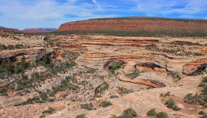
This image shows an overview of a portion of the Natural Bridges Monument in Utah, taken from the Colorado Plateau. In the lower center of the picture is the Sipapu Bridge, one of the 3 bridges within the national park.
The dominating sandstone comes from the Permian Cedar Mesa Formation that is part of the Colorado Plateau, a geologic province that extends through southern Utah and northern Arizona, northwest New Mexico, and western Colorado; with geologic units including the Lower Cutler Beds from the Pennsylvanian, Permian Organ Rock and Cedar Mesa Formation, Triassic Chinle and Moenkopi Formations, Jurassic Wingate Sandstone and the Quaternary alluvium.
Due to the regional uplift the Colorado Plateau experienced, meandering rivers progressively cut through the crossbedded sandstone – cross-bedding reflects the transport of sand by a flow of water over a river channel – of the Cedar Mesa Formation forming the bridges, leaving behind the exposed erosional surfaces carved out by the river.
Today, these bridges face many challenges: The region is still seismically active. Earthquake activity could lead to the collapse of (some of) the bridges and other small formations. Due to the low stability of the sandstone from the lack of anchoring from root structures, slope failures and slumps can be quite common and especially in the event of flash floods. Continuous wind patterns increase erosion and alter the exposed surfaces and the structure of the channel is constantly changing due to seasonal rainstorms. Sediment transport and deposition, caused by streamflow, is a major factor in channel morphology and, therefore, the ecosystem of the Natural Bridges Monument. The National Park Service constantly monitors the changes and issues that arise.
A final remark: Thanks to the entire group of the 2015 Annual AAPG Student Field Trip for making this photo possible. Members of the CSL – Center for Carbonate Research and the UM Student Chapter of AAPG for funds, and field trip leaders: Gregor Eberli and Donald McNeill.
By Kimberly C. Galvez, University of Miami – RSMAS
Imaggeo is the EGU’s online open access geosciences image repository. All geoscientists (and others) can submit their photographs and videos to this repository and, since it is open access, these images can be used for free by scientists for their presentations or publications, by educators and the general public, and some images can even be used freely for commercial purposes. Photographers also retain full rights of use, as Imaggeo images are licensed and distributed by the EGU under a Creative Commons licence. Submit your photos at http://imaggeo.egu.eu/upload/.