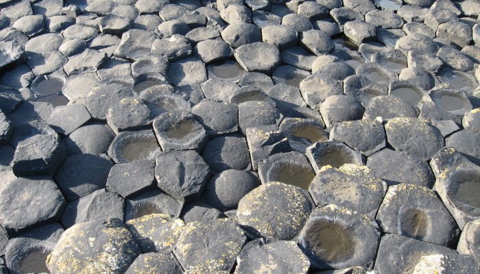
Since its discovery back in the late 1600s the origin of the spectacular polygonal columns of the Giants Causeway, located on a headland along the northern coast of Ireland, has been heavily debated. Early theories for its origin ranged from being sculpted by men with picks and chisels, to the action of giants, through to the force of nature. It wasn’t until 1771 that Demarest, a Frenchman, suggested that the origin of the world-famous headland was indeed volcanic.
“The myth goes that the Irish giant Finn MacCool once constructed a land bridge from Northern Ireland to Scotland in order to meet a rival giant,“ explains Bernhard Aichner, author of this week’s featured imaggeo image. “It is said that he used basaltic rocks from the surrounding cliffs to construct the bridge. Finn´s rival later destroyed most of the causeway, but the remnants still can be seen today as basalt columns descending into the sea.“
We now know that the hexagonal columns along the rugged Irish coastline formed some sixty million years ago, during a time when the ancestors to modern plant species started to emerge and the Earth was going through a period of warming. At the time, Antrim (a modern-day county of Ireland), was subjected to an intense period of volcanic activity as a result of the opening of the Atlantic Ocean.
The Giants Causeway is only a small part of a vast network of lava flows which extended over the Antrim landscape; much of which, through the passage of time, has been eroded away. There were three distinct periods of volcanic activity which resulted in a thick succession of lava flows which has been subdivided into the Lower, Middle and Upper Basalts.
The lavas of the Giants Causeway belong to the Middle Basalts and comprise over 40,000 vertical columns. Recently, a new model was proposed for the formation of the striking polygonal pattern formed by the columns. They formed within a lava flow, which contracted and fractured while cooling very slowly. If the loss of heat is steady, then the pattern formed is uniform, but if areas cool faster than others, the fractures develop unevenly, meaning the columns form in a variety of sizes and shapes: expect anything from pentagons to heptagons if you get a chance to visit the Causeway!
Imaggeo is the EGU’s online open access geosciences image repository. All geoscientists (and others) can submit their photographs and videos to this repository and, since it is open access, these images can be used for free by scientists for their presentations or publications, by educators and the general public, and some images can even be used freely for commercial purposes. Photographers also retain full rights of use, as Imaggeo images are licensed and distributed by the EGU under a Creative Commons licence. Submit your photos at http://imaggeo.egu.eu/upload/.