EGU Blogs

Mineralogy

From the GeoSphere Archives: The Wooden Wall

It is once again time to write about geology and classics and the incredibly important impact the geosciences had on the ancients and their way of life. My previous post on this topic can be found at my old blog location as the post: The Odyssey and Geology. I’ll begin by relating a story:

File:Themistokles.jpg

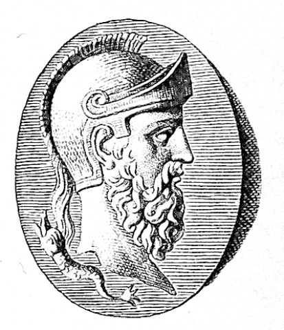
Themistocles (Wikimedia Commons)


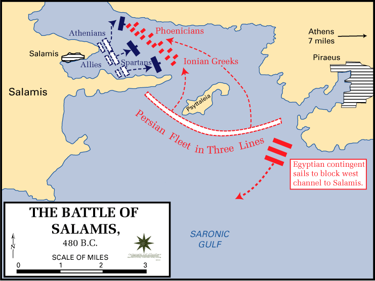
The two fleets, the Persians the the Greeks, which was composed of the navies of all the city states, but mainly Athens, met in the narrow Strait of Salamis for a final and deciding battle. The Persian king, Xerxes, was so certain of victory that he set up a throne in nearby Athens to watch the battle. The true architect of the battle though was not Xerxes, but the Athenian Themistocles, a politician and general. Indeed, it had been Themistocles who had convinced the Athenians to build a navy of over 200 additional ships in the years prior to the war and it was he who stationed the Greek navy in the Strait of Salamis, which was advantageous for the smaller Greek navy. The battle proceeded according to Themistocles’ plan and the Greeks were able to out-maneuver the Persians in the narrow strait and succeeded in decimating the Persian navy. This was a great blow to Xerxes who fled back to Persia with much of his army. The next year the Greeks were able to defeat the remainder of the Persian army driving them out of Greece and winning the war. Salamis was the turning point of the war and saved Greece from certain doom.In 480 BC the ancient Greeks were faced with their biggest threat in history: the invasion of the Persian king, Xerxes and his armies. The Greeks, despite being horribly outnumbered had fought bravely but been defeated in the Battle of Thermopylae. The Persians then advanced through Greece nearly unchecked and conquered Athens.  However, the Persians knew that to fully conquer Greece they would have to do so at sea as well as on land. Things were looking pretty grim for the future of ancient Greece at this point.

File:Battle of salamis.png
Source: Wikimedia Commons

The hero of Salamis, Themistocles was a very persuasive politician as well as tactician. In fact, it was he who convinced the Athenians to build the 200 triremes (ships) that made of up the bulk of the Greek navy and can be credited with saving Greece. The credit cannot be only given to Themistocles though. In fact, the idea came from the Oracle of Delphi. The Greeks were very worried about the impending Persian invasion and decided to consult the oracle for advice on how to win the war. The oracle cryptically answered along the lines of the “wooden wall will save you”. Clearly, this answer could not refer to the building of an actual wooden wall since that would be stupid and obviously could burn down. Themistocles interpreted the oracles advice to mean build a navy. Unfortunately, the ancient Greeks had the same problem with national defence requisitions as governments do today and money for such a venture was not easily at hand. However, geology was going to come to the Greeks rescue in the form of a major silver discovery at Laurium, a small mining community just south of Athens, providing the Athenians with enough money to afford a new navy. Without the discovery at Laurium it is possible the navy would never have been built and ancient Greece would have fallen into Xerxes hands. Ergo, geology saved ancient Greece from total domination by the Persian empire.

So now what about Laurium?

File:Mineurs grecs 2.jpg
Miners in Laurium. They were all slaves. (Source: Wikimedia Commons)
Google Maps

The Laurium silver mines are located just south of Athens and are world renowned for the excellent mineral samples the area still produces in addition to its storied past. The mineralization is of lead, zinc and silver and is associated with the emplacement of an igneous body within metamorphosed sediments. The ore occurs mainly within marble especially at the contact with other metamorphic or igneous rocks (www.mindat.org). The list of minerals found in the Laurium mining district is a mile long and it is actually the type locality for about a dozen minerals as well, making it a world class mineralogical site. The mineral Laurionite is named in honour of the location. In addition to the minerals occurring in the mines there are a host of others that occur in the ancient slag piles left by the Greeks. The slag has reacted with the sea water used in processing the ore in ancient times to produce a suite of new and unusual minerals there as well.

Agardite, Laurium, Greece (Source: www.mineral-forum.net – Used with permission)
Diaboleite, Laurium, Greece (Source: www.mineral-forum.net – Used with permission)
Conichalite, Laurium, Greece (Source: www.mineral-forum.net – Used with permission)
Nealite, Laurium, Greece (Source: www.mineral-forum.net – Used with permission)
Annabergite. Larrium, Greece. (Source: www.mineral-forum.net – Used with permission)

The ancient ore processing techniques of the Greeks were obviously primitive relative to today’s, however, they were still able to extract both lead and silver from the ore. The process essentially involved numerous washes with water in a sloped basin. The heaviest material was collected and smelted, and the resulting slag was carted away and dumped. Since then the slag has had a few thousand years to oxidize and this process has resulted in the growth of all sorts of interesting minerals like the ones pictured above. Laurium is still geologically relevant today from the perspective of the mineralogist or mineral collector as the area still produces some world class specimens.

It has always amazed me how deeply geology is integrated with our lives today, what with our dependence on natural resources for nearly everything. However, it would appear that this is not a new phenomenon and that geology always has been and will always be a crucial part of our lives.

Thanks for reading!

Matt 

The Mysteries of Maqarin

We all know that cement is a man-made substance and therefore cement is always synthetic right? Wrong!

In the unusual case of Maqarin, Jordan the stars aligned to produce natural cement and many of the “synthetic” minerals found therein. The Maqarin site has been the subject of an intense geological investigation by a consortium of over 100 researchers for years in an attempt to try and understand this system and its implications. A fairly good overview is available here.  Maqarin is located in  north-east Jordan, near the border with Syria, in the river valley of the Yarmouk River. The valley is deeply incised allowing a good view of the stratigraphy. There are also several springs coming out of the sides of the valley wall and it is these and their relationship to the unusual geology that make Maqarin so interesting.

A map of Jordan. The location of Maqarin is starred.

A map of Jordan. The location of Maqarin is starred. (Source)

Geologic History

The geologic history of the Maqarin site is very interesting and in many ways unique. Indeed, it was a unique combination of geology and geological events that led to its formation.

1. During the Cretaceous bituminous marls are formed. Basically, rocks that are full of bitumen and calcium carbonate. This rock has up to 20% organic matter! Bitumen forms when organic matter is heated during lithification and is similar to oil. It will burn. The marl is a white, chalky mineral primarily made of CaCO3. There is also about 10% sulphate, which becomes important later on in the geologic history.

2. Overlying the bituminous marls are chalky limestones that were deposited in the Tertiary.

3. The upper unit is basalt, which was deposited during the Pleistocene.

4. The bituminous marl underwent “pyro-metamorphism”. Basically, the rocks were heated to a point where the carbonate rocks cooked and formed high temperature cement minerals such as portlandite, ettringite and thaumasite. The heating though was not due to burial but actually from spontaneous combustion of the bitumen (Khoury et. al., 1992). The presence of sulphate allowed these minerals to form and better simulated a modern cement environment. When the marl, which is CaCO3, is combusted CaO or lime is formed. Then the infiltrating groundwater allows portlandite to form, which then reacted with the suplhates and silicates present to form the other cement minerals.

5. The rocks in the area are all highly fractured allowing water to easily seep through the site. This has led to weathering of the cements. The water seeping through the sites discharges near by and has a pH of 13!!!! The water that seeps through the “cement zone” of the Maqarin site picks up all sorts of dissolved ions and minerals. Remember that heating carbonate + water gives Ca(OH)2. Therefore, there is a huge supply of hydroxide available to raise the pH.

These 5 steps created the Maqarin analogue site as we see it now. Everything had to be perfect for it’s formation to happen:  the rocks had to have the right chemistry, pyro-metamorphism had to occur and, the hydrogeology had to allow water to infiltrate and react with the rocks to produce the hyperalkaline springs. See the references below for a more detailed description of the geology and mineralogy of Maqarin.

An image of the Yarmouk River Valley from the Jordan Times. Notice the bedded cliffs along the river. At Maqarin it is these cliffs that have the springs in them. In the distace you can also make out the sraker, overlying basalt. (Source)

Some Geochemistry

I mentioned the “hyper-alkaline springs” above. These springs are super interesting to geochemists, since there not very many places on Earth where we can find springs of highly elevated pH. Indeed, it is much more common to find acidic springs than alkaline ones. However, the springs of Maqarin have exceptionally high pH’s. Why?

The alkaline springs, which flow out of the hillsides at Maqarin, formed due to the unique combination of the hydrogeology, structural geology and mineralogy of the site. As the water infiltrates through fractures in the rock it intially dissolves NaOH and KOH followed by Ca(OH)2, which is the cement mineral portlandite. All of the OH ions that enter solution contribute to the raising of the pH to around 12.5. This now caustic water is then able to react with other minerals and pick up a lot of metals such as uranium, chromium, vanadium and other exotic elements that would usually be insoluble and hence difficult to transport (Khoury et. al, 1992).

The stable isotopes also tell and interesting story about the origins of the water and its pathways at Maqarin. In arid climates, such as Jordan, the groundwater often reflects evaporation that took place either before or during recharge.  The waters of Maqarin plot below the local meteoric water line, which is indeed indicative of evaporation before or during recharge of the groundwater. However, there is more to these waters than just evaporation. In fact, the hydration of the cement minerals, such as portlandite, can cause an 18O enrichment, which can also be seen in the Maqarin groundwaters, although it is difficult to differentiate this effect from that of evaporation, which also produces the same trend (Khoury et. al. 1992).

Untitled-1

Plot of 18O vs 2H in the hyperalkaline springs of Maqarin, Jordan. The local meteoric water line (Irbid) and the eastern Mediterranean meteoric water line are both shown. Modified from Khoury et. al., 1992.

Why study Maqarin?

We need to understand how cement will behave over long time scales because in most nuclear waste storage or carbon sequestration designs one of the primary barriers between radionuclides/CO2 and the environment are the engineered barriers, many of which are made of cement. In fact, in a repository setting cement is everywhere. It will be used to contain the waste itself, plug up fractures, reinforce structures, and eventually to seal the whole place up. Sealing the place up water-tight (hopefully radio-nuclide tight also) is great, but what happens to the seals when they are subjected to a million years of groundwater flow? Well, the modelling suggests that…. Wait, did I just say modelling? You mean we rely on computer generated geochemical models to tell us what might happen in a number of scenarios? We don’t know exactly what will happen to all that cement that is plugging up a waste site?

An artists depiction of a deep geologic repository for low and intermediate level radioactive waste. (Source)

Enter Maqarin. Maqarin is such an interesting place because “cement” occurs naturally here and it provides a rare opportunity for researchers to actually see how cement and the minerals composing it behave over long time scales when subjected to weathering processes. Therefore, the site can be considered an analogue for the future behaviour of cement in the environment. Indeed, the hydration process that occurs in Maqarin when the groundwater reacts with NaOH, KOH and Ca(OH)2 is exactly what will happen when “man-made” cement is exposed to groundwater. Understanding the geochemistry and hydrogeology of a site like Maqarin gives real-world insights into the outcome of our modelling and we can take the data collected at places like Maqarin and compare them to our model results to verify its accuracy. Furthermore, using observations and empirical data to make conclusions about the future of waste repositories adds a whole new level of confidence in their design or identifies possible weaknesses.

In summary, since radioactive waste storage facilities, which are designed to have million year lifespans, are made of cement it is crucial that we know what will happen to them over long time periods. However, the problem is that modern cement is just that: modern. Therefore, we don’t really know how it will behave in certain environments or when conditions change, or during an ice age, etc, etc. In order to solve this problem we must turn to the next best thing, which is a natural site, such as Maqarin, that mimics the environmental conditions we are looking for and hopefully it can answer some of these questions. Hence, the beauty of the natural analogue.

Thanks for reading,

Matt

References

Khoury, H.N., Salameh, E., Abdul-Jaber, Q., 1985. Characteristics of an Unusual Highly Alkaline Water from the Maqarin Area, Northern Jordan. Journal of Hydrology 81, 79–91.

Khoury, H.N., Salameh, E., Clark, I.D., Fritz, P., Bajjali, W., Milodowski, a. E., Cave, M.R., Alexander, W.R., 1992. A natural analogue of high pH cement pore waters from the Maqarin area of northern Jordan. I: introduction to the site. Journal of Geochemical Exploration 46, 117–132.

Guest Post – Mike Power – Using surficial geochemistry to detect buried mineral deposits

Finding the next big mineral deposit is a dream of many geologists past, present and future. However, in the past hundred years or so, many of them close to surface have already been found and developed. This is because they can be found relatively inexpensively by traditional methods such as geochemical surveys, shallow geophysics, drilling, and a lot of luck. In the 21st century, mineral exploration is focussing on methods to find deeply buried mineral deposits, ones that can lie almost 800m beneath the surface!

To develop new methods for finding such deposits, I travelled up to northern Saskatchewan, Canada, to the Athabasca Basin, which is home to the world’s highest grade uranium deposits. As part of my M.Sc. thesis at the University of Ottawa, I completed surficial geochemistry surveys above two different uranium (U) deposits – one (Phoenix) of which is “unconformity-related”, which means it lies between the Paleoproterozoic Basin and underlying Proterozoic basement rocks at 400 m depth below the surface. The other (Millennium) is a “basement-hosted” deposit, which means it lies entirely in these basement rocks at nearly 750 m depth. When I say surficial survey, I mean taking materials from the surface or near-surface environment – soils, tills, water, gas, and sandstone, and testing them with various geochemical methods to see if we can detect signatures possibly related to the U deposits beneath (fieldwork photo, Figure 1). For soils, sandstones & tills, we used total and partial digestion with various acids to leach out what is considered the “mobile” trace metal fraction that may have migrated from an ore deposit to the soil. For water, we looked at trace metals and also tritium, a known decay product of U. For gases, we looked for dissolved gas (helium) in water-filled drill holes, as this is also a known decay product of U and its daughter products.

Fieldwork

Fig. 1: Here I am sampling above the Phoenix uranium deposit in September 2011, holding an auger with the various soil horizons we collected for sampling.

At the Phoenix survey site in 2011 & again in 2012, we discovered distinct metal anomalies in soil, till and sandstone (both humus, the organic-rich top fraction you might find in your local forest, and in B-horizon, the rich, brown soil a foot or so deeper) for U – but also Pb, Ni, Cu, Co, Mo, W, and Ag in these media (see Fig. 2a & 2b). Many of these elements are what are considered “pathfinder” metals for U, so will be enriched in the deposit itself or behave in a similar geochemical manner. Geochemical anomalies (high values) only exist when compared to background values that are low, whether a background station, or the mean + 2 σ (standard deviations) of each metal population, so any we considered had to meet this threshold.  We found these anomalies directly above the deposit itself, and also above the location of a major ore-hosting fault, using a “transect” sampling method, or taking samples in a line across a targer. This allowed us to survey across the surface trace of the deposit perpendicular to the direction of the last major ice flow event, so this would not affect our results, or “smear” metals occurrences down-ice.

Untitled

Fig. 2a: Contoured geochemical results for U in aqua regia digestion of humus soil samples from 2011-2012 and partial leach of the uppermost sandstones of the Manitou Falls Formation. The sandstone map showing interpolated U abundance from partial leach in were used as an independent base on which the soil transect results from aqua regia digestion were plotted. The surface traces of Zones A and B1 are also outlined for reference.

U Resampling GEEA_edited

Fig 2b: Detailed 2012 humus soil sampling near the 2011 site (PHX028, furthest left on graph) that showed the highest U value. The results, (samples PHX231-237 & background measurement in 2012) confirm the reproducibility of anomalous U observed last year.

Based on the results we obtained at Phoenix, we decided to see if we could detect any anomalies in these materials that might be related to Millennium- the much deeper deposit. Using leaches on the humus and B-horizon soils, we were also able to see anomalies of U, Pb, Ni and Cu, which was encouraging, as these occurred over the deposit, and also over the surface projection of the ore-hosting fault, which was interpreted to come to surface based on a 3D seismic geophysics survey. Even more exciting, at this site, however, is that we obtained values of 4He (the main isotope of He) that were more than 700 times atmosphere in drill holes intersecting the deposit (Fig. 3)! (Ed Note: 4He is a product of uranium decay – the alpha particles that Uranium emits as it decays are, in fact, 4He nuclei. Therefore, an anomalously high 4He value is a good indicator of nearby Uranium decay.) It was important that in drill holes that weren’t near the deposit, we did observe atmosphere values, as to have a good measurement of background. Having anomalies in trace metals in the soils was one thing, but now we observed gas anomalies in water in the same locations. This led us to conclude that there was a high possible of redistribution and upward migration of U ore related metals and decay products from the deposit at depth.

Fig 10 (1)

Fig 3: Ratios of 4He/36Ar in the sample and 4He/36Ar in the calculated value for air-saturated water (ASW) vs. the inverse value of the abundance of 4He in each sample. Three samples (MLN G05-07) display extremely radiogenic values of 4He, while the typical atmosphere value is plotted (as a 4He/36Ar ratio of 1). The radiogenic 4He observed could possibly be sourced from the U deposit at depth

Now that we had our hypothesis of upward migration of metals (Phoenix) and both metals & gases (Millennium), could we guess if these processes are happening in modern times, or happened long ago? When we look at lead isotopes in humus at Phoenix, we observed that they show what is know as a common lead signature – which means lead not related to radiogenic, or radioactive, lead associated with active uranium decay. Therefore, we assume that this system is closed and metals have not migrated in many thousands (or millions) of years. At Millennium, however, we observe radiogenic He levels in modern-day groundwaters above the deposit, suggesting these products are actively migrating away from the deposit. So some deposits are closed at present day, and some are open. It just depends how you look at them!

That the geochemistry of surficial materials can be used to explore for deeply buried mineral deposits is a powerful idea, and much work still needs to be done depending on the deposit type and surficial environment being explored in. It is cheaper compared to geophysics and radiometrics, and can be completed with a relatively smaller crew of just a few people. And just like other techniques, it isn’t always going to find the next big deposit, but can be another useful instrument in the explorationist’s toolbox.


IMG_6579

Michael Power is an MSc student in exploration geochemistry at the University of Ottawa in Ottawa, Canada. He did his undergraduate degree at Memorial University in Newfoundland, Canada. Michael has worked in a range of mineral and petroleum exploration related positions during and after his undergrad, from the oil sands of Alberta to the gold districts and offshore oil fields in Newfoundland. His MSc research is trying to better understand how geochemistry of surface materials can detect deeply buried U deposits. Tweets as @mikeyp22


Geology Photo of the Week #34

My apologies for the slight blogging hiatus over the last little while. I have been preparing for a conference and then attending and so I had to put blogging on the back seat for a few weeks to prepare properly. However, the conference is done, my talk is given so now I can get back to blogging…at least until the next one…which starts on Tuesday (tomorrow). Luckily, I get to just watch at this one and don’t have to go through the effort of actually preparing to say anything. This conference is a very focused and small event that specifically concerns the geoscience of the proposed low-level radioactive waste storage facility in the Bruce Peninsula.

The photo for this week is known simply as the “The Candelabra”. It is one of the best if not the best specimen of blue-cap tourmaline in existence.

Blue cap elbaite at the Smisthonian Museum in Washington D.C. (Photo: Matt Herod)

Of course, the Canadian Museum of Nature has a pretty nice one also:

Blue cap at the Canadian Museum of Nature (Photo: Matt Herod)

Both of these unbelievable specimens come from the same location, which is the Tourmaline Queen Mine in Pala, California. The mine is still a producing gem mine to this day and if you would like to find out about its colourful history click the link above (pun intended). The geology of the mine is no less fascinating than the crystals it produces. It is located in a pegmatite, which is a class of igneous rock that can often be a source of large crystals and/or unusual mineralogy. Pegamatites are a type of intrusive igneous rock that can form from a melt that contains a high percentage of volatiles, such as water, which lowers the viscosity of the melt and allows for the formation of large crystals compared to those formed from a higher viscosity melt. Some crystals can be several metres in length. Furthermore, pegmatites can often contain a high concentration of incompatible elements such as lithium, tungsten and boron. These elements, among others, don’t normally form minerals easily, and are known as lithophiles or incompatible elements. When they are forced to crystallize in a pegmatite that has branched off a large batholith the result can often be unusual minerals such as toumaline or spodumene.

The reason that the tourmalines from the Tourmaline Queen have the “blue cap” is because of their chemistry. In the case of the blue caps there is a sudden shift from manganese rich to iron rich, which causes the sudden change in colour.

Thanks for reading,

Matt

p.s. This post represents something of a milestone for this blog as it is my 50th post since this blog began in October 2012. I am looking forward to another 50!