Nestled among the high peaks of the Karakoram, in a difficult to reach region of China, lies Kyagar Glacier. It’s trident-like shape climbs from 4800 to 7000 meters above sea level and is made up of three upper glacier tributaries which converge to form an 8 km long glacier tongue.
Until recently, it’s remoteness meant that studying its behaviour relied heavily on the acquisition of data by satellites. The installation, in 2012, of an automated monitoring station yielded photographs and other data which, combined with better satellite observations, give a detailed insight into the nature of an otherwise enigmatic glacier.
The flow of glaciers
Despite their impenetrable fortress-like appearance, glaciers are constantly on the move. Due to the force of gravity acting on the thick pack of ice, glaciers flow, albeit very, very slowly. The ice deforms under its own enormous weight, creeping slowly down valleys and mountain sides.
The exact position of a glacier’s snout is also affected by the amount of snow that accumulates on its surface. When the rate of evaporation of snow exceeds the amount added to the glacier, it retreats. Rising global temperatures mean that glaciers worldwide are shrinking at unprecedented rates.

Kyagar Glacier on 29 March 2016, as seen from the ESA Sentinel-2A satellite. The glacier-dammed lake of approximately 5 million m3 is visible to the east of the glacier terminus. The curved scale bar up the west branch indicates the longitudinal profile used for surface velocity and elevation analysis, and the inset shows the monitoring station located about 500 m upstream of the glacier terminus. Taken from V.Round et al., 2017 (click to enlarge).
But, the remote glaciers of the Chinese Karakoram are bucking the global trend. Owing to localised increases in winter precipitation between 1999 and 2011, they are maintaining a steady ice-thickness (or even advancing slightly).
The way in which many glaciers of the central Asian mountains flow is also unique. While the majority of glaciers slide down valleys at a relatively steady rate, about 1% experience glacier surges. Long periods of quiescence where flow is extremely slow are punctuated by times (which can last months or years) of accelerated gliding and transport of material.
During active surge periods a glacier’s snout can lengthen and thicken, blocking rivers and forming ice-dammed lakes. If the dam containing the lake fails, a glacial outburst flood (GLOF) occurs, presenting a serious threat to downstream communities.
Mysterious floods
A record of devastating floods along the Yarkand River – which Kyagar Glacier feeds into – exists from as far back as the 1960s. But the origin of the floods remained a mystery for many years. While periods of thickening and advance had been recognised in Kyagar as early as in the 1920s, it wasn’t until 2012 that it was characterised as a surge-type glacier; finally establishing the link between the down valley flood events and the glacier.
In order to manage the hazard presented by future GLOFs, it is important to fully understand the surge dynamics of Kyagar. Using a combination of satellite images and data, as well as images and weather records made by the automated observation station, a team of researchers have been able to establish the speed at which Kyagar moved between 2011 and 2016.
The study period also coincided with a recent surge cycle at Kyagar, giving the scientists their first detailed glimpse of how Kyagar moves and forms hazardous ice-dammed lakes.
Kyagar’s surges and GLOFs
Before 2012, Kyagar was in a quiescent phase (which had lasted at least 14 years). During that time the glacier snout was thinning and ice was built up in an area towards the top of the glacial tongue, forming a reservoir.
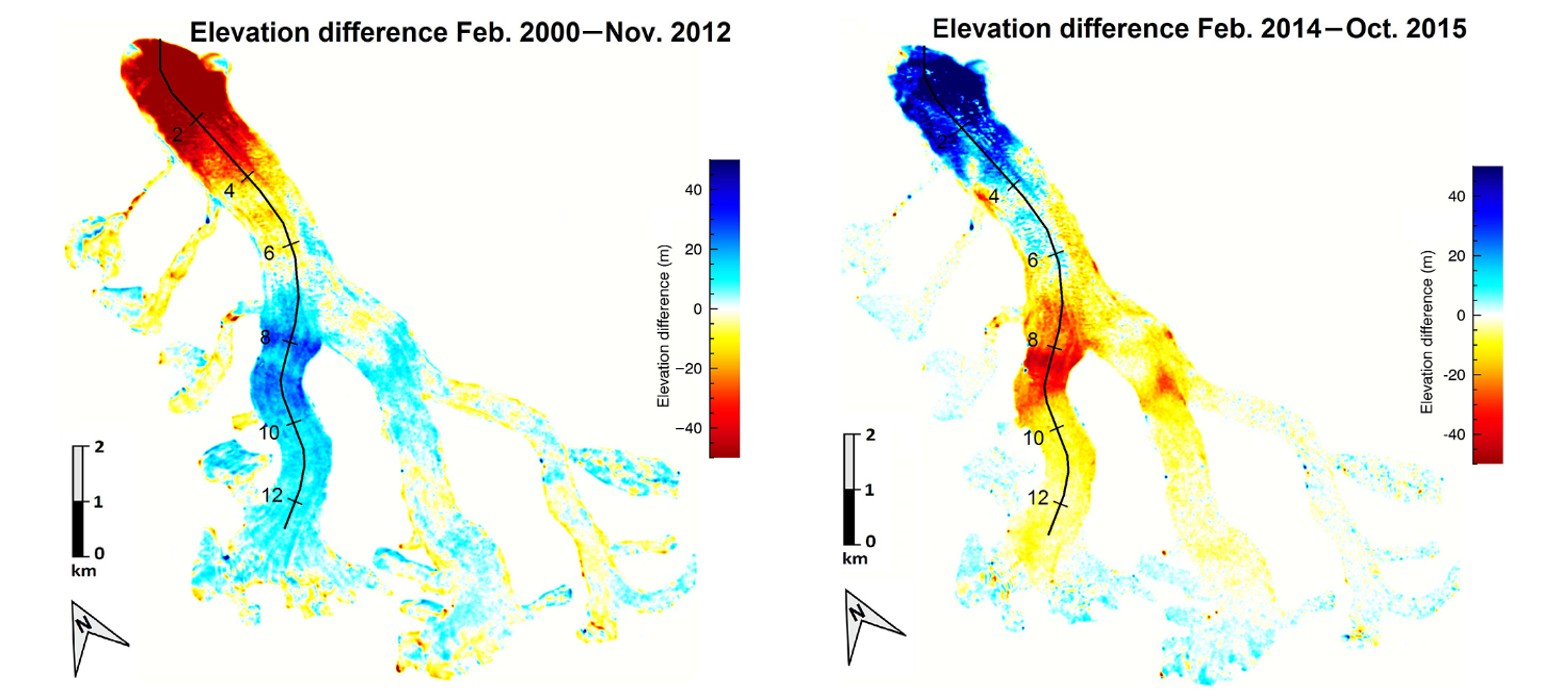
Glacier surface elevation changes during the surge from subtraction of two TanDEM-X DEMs. (Left) During the quiescent period, snow accumulate in an area towards the top of the glacial tongue, while the snout thinned. (Right) During the surge period this pattern was reversed. Modified from V. Round et al., 2017 (click to enlarge).
Gradually after that, the thickness of ice at the snout began to increase, as ice moved from the reservoir higher up in the glacier where it had accumulated previously.
The velocity with which the glacier moved forward also increased. Between April and May 2014 speeds doubled compared to the maximum speeds recorded before then. Despite a few fluctuations, speeds continued to increase overall, peaking in mid 2015. In that time, Kyagar gained over 60m of ice at its snout.
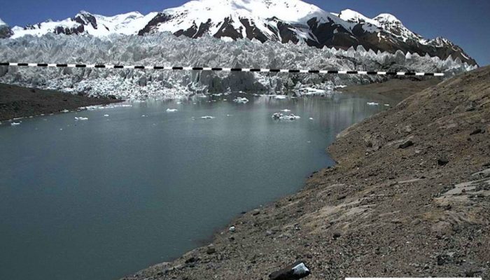
Photographs from the monitoring station revealed that a lake began to form upstream from the glacier’s terminus in December 2014. It grew steadily throughout the spring and summer and drained, abruptly, through channels carved out below the glacier in July 2015.
By September 2015 the lake began to fill again. Ten months later, in July 2016 it reached its peak volume of 40 million ㎥ (equivalent to the amount of water held in 16,000 olympic sized swimming pools) and drained suddenly shortly after. It refilled over the course of the next month, reaching a volume of 37 million ㎥ , and once again drained abruptly in August 2016.
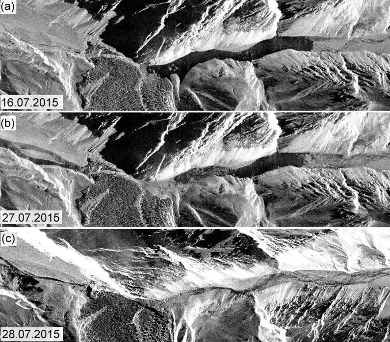
Radar backscatter images of the glacier terminus showing the lake (a) 11 days before drainage, (b) just after the start of drainage, and (c) after the lake drainage. Lake drainage clearly occurred through subglacial channels, rather than through dam collapse or overtopping. Images from TanDEM-X data provided by DLR. Taken from V.Round et al., 2017 (click to enlarge).
What causes Kyagar to surge?
Not unlike other surge-type glaciers, Kyagar seems to have an inefficient drainage system at its base. It is particularly poor at transporting ice from its reservoir to its snout in a regular manner. Instead, it does is cyclically, through surges.
During quiescent periods interconnected tunnels at the base of the glacier carry water away efficiently. During surge periods, the tunnels turn to cavities which are poorly connected by very narrow passages, meaning material isn’t carried away from the glacier easily. This leads to a pressure build-up, and only when the pressure is high enough, is water released, lubricating the glacier bed and encouraging sliding over large areas.
Scientists aren’t certain what causes Kyagar to behave in this way. It is likely a combination of factors: the glacier tongue is relatively flat compared to the steeper slopes in the accumulation area, while the underlying geology and regional climatic conditions also play a role.
What does the future hold?
Historical records of glacial advance and lake formation at Kyagar suggest surge periods occur every 15 to 20 years. Unless there are major changes to the rate at which snow accumulates on the glacier, the nest quiescent period is expected to last until, at least, 2030.
The current risk of GLOFs remains high and will remain so for the next few years, as the glacier snout is still slightly higher than normal and transport of ice from the reservoir is ongoing.
Whether a lake will form (and how large it will grow) during future surge periods depends on the height of the ice dam and how efficiently water is drained away through the subglacial channels.
Regular satellite images, taken during summer periods, are needed to continually assess the risk of GLOFs and to prepare downstream communities.
By Laura Roberts Artal, EGU Communications Officer
References
Round, V., Leinss, S., Huss, M., Haemmig, C., and Hajnsek, I.: Surge dynamics and lake outbursts of Kyagar Glacier, Karakoram, The Cryosphere, 11, 723-739, doi:10.5194/tc-11-723-2017, 2017.
Gardelle, J., Berthier, E., Arnaud, Y., and Kääb, A.: Region-wide glacier mass balances over the Pamir-Karakoram-Himalaya during 1999–2011, The Cryosphere, 7, 1263-1286, doi:10.5194/tc-7-1263-2013, 2013.