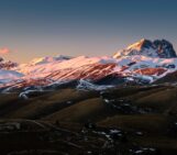
“Endless fold”, by Jens Rößiger, was taken in the Pyrenees – its location is approximately 42°19’17.29″N, 3°18’49.02″E. This image is distributed by the European Geosciences Union under a Creative Commons licence.
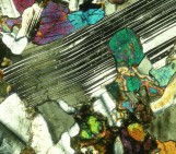
This fold is part of the metamorphic core of the Pyrenees. The shear zone is almost vertical, producing a small parasitic fold (a smaller fold within a larger one), which looks almost as if it continues into the sky. The metamorphic sediments are about 500 million years old and have been deformed several times, most recently during the alpine orogeny. The alpine orogeny was period of extensive mountain building that occurred towards the end of the Mesozoic as the African and Arabian plates collided with the Eurasian, resulting in the formation of the Alpide belt. While the map below only shows the Mediterranean portion of the Alpide belt, this stretch of mountains extends much further East and includes the Himalayas.

The plate tectonics of the Mediterranean, responsible for the alpine orogeny that spans the region (orange) [Source: Wikimedia Commons].
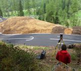
The fold above lies within the Seira Negra (Black Series) at Cap de Creus, Spain. Much of this region is composed of mylonites (fine-grained rocks that have been through ductile deformation), pegmatites (highly crystalline igneous rocks with crystals >2.5 cm wide) and schists (medium-grade metamorphic rocks, with a large proportion of platy minerals – these are responsible for their sheen). The metamorphic grade of rocks in Cap de Creus decreases from north to south. An overview of the region’s metamorphic geology is given in the map below:

Geology of the Cap de Creus area – Jens’ photo was taken just north of the lighthouse (click to enlarge) [source: Carreras, 2001].
Rocks in Cap de Creus have been subject to a lot of shear stress through faulting and other orogenic processes. These processes have caused high strain in the rocks and extensive deformation. The “endless fold” above is composed of quartzite, with numerous quartz veins running throughout it. The fold is caught up in one of the many classical Variscan shear zones found in the area. Variscan shear zones are so named because they formed during the Variscan orogeny, a mountain building event in the late Palaeozoic, when Eurasia and Gondwana collided to form the supercontinent, Pangea. Relatively young volcanic intrusions (pegmatites) exist within the fold, and some of these have been deformed since, as the mountain range continues to build.
References:
Bons, P.D., Druguetb, E., Hamann I., Carreras, J. and Passchier, C.W. (2004). Apparent boudinage in dykes. Journal of Structural Geology. Vol. 26, pp. 625–636.
Carreras, J. (2001). Zooming on Northern Cap de Creus shear zones. Journal of Structural Geology. Vol 23, pp 1457-1486.
Imaggeo is the EGU’s online open access geosciences image repository. All geoscientists (and others) can submit their images to this repository and since it is open access, these photos can be used by scientists for their presentations or publications as well as by the press and public for educational purposes and otherwise. If you submit your images to Imaggeo, you retain full rights of use, since they are licensed and distributed by the EGU under a Creative Commons licence.