Geology for Global Development followed Professor Iain Stewart’s BBC two TV series (June 2013), ‘Rise of the Continents‘ with interest. In the first episode, Iain mentioned something that really caught our attention – the strange volcanoes along the East African rift valley and their effect on soils and wildlife.
Each year, as the rainy season transforms the Serengeti, a nutrient hotspot emerges: a small patch of grass that is exceptionally rich in calcium and phosphorous, essential nutrients for healthy calf development. Millions of wilderbeast are born here at the end of their mothers long migration, and for a short while, this hotspot hosts the largest concentration of grazing herbivores on the planet.

A look at the Ol Doinyo Lengai lava down the microscope, under crossed polar light, reveals some unusual minerals (combeite, nepheline, aegirine, sodalite). Source: T Peterson, Mindat. More information here.
The grass in this part of the Serengeti is unusual because it lies on soil forged by one of Africa’s most explosive volcanoes, Ol Doinyo Lengai, known to the Maassai as the ‘Mountain of God’. As Iain Stewart squeezed droplets of acid onto the lava, bubbles of carbon dioxide were released, indicating the presence of carbonate minerals. This is the world’s only active carbonatite volcano.
The sodium and potassium carbonate minerals of the Ol Doinyo Lengai lavas are unstable at the Earth’s surface and susceptible to rapid weathering. Within a few months of erupting, lava flows turn from black into a pale powder. The resulting volcanic landscape is different from any other in the world.
To form lava with such strange properties, the rock must have melted at low temperature and high pressure. At only 500-600 degrees, carbonatites are relatively cool by lava standards. The volcano is fed by the mantle superplume that stretches out beneath the rift valley, pulling Africa apart. The red sea will one day (in the very distant future) flood this plain, splitting the region in two.
- Ol Doinyo Lengai eruption 1966, from U.S. Geological Survey.
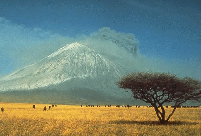
Ol Doinyo Lengai lies at the end of a chain of extinct volcanoes and its crater rim sits atop the products of previous eruptions. Evidence of previous activity is rife, so an eruption was never unexpected. Geologists suspected that a sudden increase in daily earth tremors felt in Kenya and Tanzania, reaching up to 6.0 on the Richter scale, were indicative of the movement of magma through the Ol Doinyo Lengai. The volcano erupted shortly after, on September 4, 2007, sending a 5Km plume of ash and steam at least 18 kilometers downwind and covering the north and west flanks in fresh lava flows.
The eruption ruined crops and forced local residents, mainly herders, to flee with their livestock. The people living nearby are concerned that it will happen again.
The mantle plume beneath East Africa is of great environmental importance. This region of intense geological activity has resulted in problems with water contamination within the rift valley, as well as producing volcanic and seismic hazards. However, the strange nature of the carbonatite lava has created a nutrient hotspot – one that draws both animals and people into the region.
Recommended Reading:
Nasa have an information page on Ol Doinyo Lengai, which includes some very clear aerial photographs.
The Ol Doinyo Lengai Website includes photographs and information on past eruptions.