EGU Blogs

Ocean

Photo of the Week – Salt Coral

Photo of the Week – Salt Coral

The photo posted below is a really cool one. Interestingly, enough I have been getting into podcasts lately. They are great during my bus ride to and from work every day. One of the podcasts that I like is Neil de Grasse Tyson’s Star Talk Radio. Anyway, the other week Star Talk had a pretty good discussion about salt and the role it has played in developing human history. Check out the episode in two parts here. Arguably as one of the most important economic minerals of all time, although it may not seem so today.

That said, having read the book Sugar, Salt and Fat I would argue that salt retains its title as the most important of all economic minerals even to this very day! Anyone else have an opinion on this?

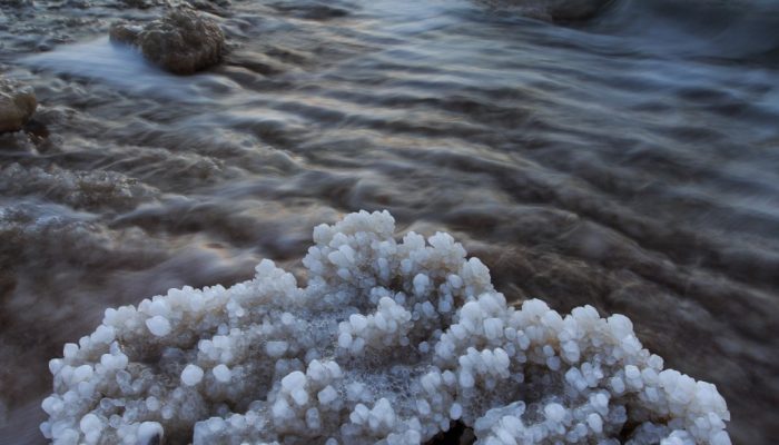
I digress though. The image below shows an incredible salt concretion on the shore of the hypersaline Dead Sea that has been formed by sea spray that has evaporated creating this magnifcent shape. Despite the title it is not actually coral.

Walking along the shoreline of the Dead Sea, you can find some magnificent objects, like this coral made of salt. Combine that with the beautiful scenery and amazing lighting at dawn and you get this amazing photo. Source - Salt Coral by Zachi Shtain

Walking along the shoreline of the Dead Sea, you can find some magnificent objects, like this coral made of salt. Combine that with the beautiful scenery and amazing lighting at dawn and you get this amazing photo. Source – Salt Coral by Zachi Shtain

Geology Photo of the Week #52 – Looking from the past to the future

This weeks photo is a beautiful yet sad reminder that Arctic research and work is still a dangerous undertaking just as it was for the early Arctic explorers.

The following text is by Vladislav Petrusvich: Canadian research icebreaker CCGS Amundsen by Beechey Island in 2013 after tragic event when a researcher (Klaus Hocheim), captain and a helicopter pilot were killed in a tragic helicopter crash during scientific cruise. Beechey Island is related to ill-fated Franklin expedition that overwintered at the island. The shot is made through the remaining wall of a supply depot used by the search parties looking for disappeared Franklin expedition in 19th century.

Beechey Island is located in the Northwest Passage and was named after the artist on board Capt. William Perry’s Arctic exploration in 1819. Beechey Island was next visited by the Franklin expedition in 1845 as Sir John Franklin’s first winter encampment aboard the HMS Erebus (discovered in 2014) and Terror (not yet found). Recent archaeological investigations by Parks Canada have found three mummufied bodies that had died of lung disease and lead poisoning, which appeared to be from the lead solder used in the canning of food although it now appears that the lead may be from the water distillation system on the ships.

Geology Photo of the Week #48

This edition of the photo of the approximate week (plus or minus 1 – sorry for my tardiness) is very cool in that it shows when earth processes that are invisible suddenly become very visible. In this case the submarine volcano, El Hierro, is erupting and instead of the usual bursting lava and fireworks display the only evidence of the turmoil going on is this discolouration at the ocean’s surface caused by volcanic ash particles and gases. Despite the submarine location of the volcano it’s activity was by no means hidden as numerous earthquakes indicated that an eruption was imminent.

Suspended volcanic material and gasses caused differents colors in the sea water during the 2011-2012 submarine eruption in El Hierro (Canary Island, Spain)

Suspended volcanic material and gasses caused differents colors in the sea water during the 2011-2012 submarine eruption in El Hierro (Canary Island, Spain) by Laura García-Cañada. (Source)

Geology Photo of the Week #44

For a bit of a change of pace the photo of the week this week isn’t a photo at all. Rather it’s a fascinating model output showing ocean surface currents in the North Atlantic. The Gulf Stream is clearly visible as it flows past Atlantic Canada and out towards the middle of the north Atlantic. I am guessing that colour scheme has something to do with current velocity or mass flux or something. Anyway, I think that red means a bigger current than blue.

Modelling is something that I have written briefly about before and am starting to get involved with in my own work. It’s a fascinating field although I believe that all model results should be taken with a grain of salt given that they try to mimic and quantify what is actually happening in nature but cannot always incorporate all of the inter-relationships that exist between the variables. This makes them only representations of what is actually occurring in the real world. However, the insane level of complexity in real systems makes models the only way to try and understand processes that we can’t observe easily. As we learn more the model can then be adjusted to incorporate new linkages and their importance more accurately.

Enough of my ranting, enjoy this unique and beautiful model output of the north Atlantic’s currents.

3b3367d54c0e5eccb464f3b770d1f53b

Surface currents in the North Atlantic– by Erik Behrens, GEOMAR, Kiel, Germany Snapshot of surface speed in a eddying (0.05°, VIKING20) ocean sea-ice model resolving important mesocale eddies and filaments explicitly.