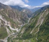
The Annapurna massif is located in an imposing 55 km long collection of peaks in the Himalayas, which behave as a single structural block. Composed of one peak (Annapurna I Main) in excess of 8000 m, a further thirteen peaks over 7000 m and sixteen more of over 6000 m, the massif forms a striking structure within the Himalayas. Annapurna South (pictured in today’s featured image), the 101st tallest peak in the world, towers 7219 m above sea level.
Glaciers in High Mountain Asia, a region that includes the Himalayas, contain the largest volume of ice outside the polar regions. The water trapped, as ice, in the glaciers of the Himalayas is an important source of drinking water, water for irrigation and water for hydropower generation throughout the region. As the Earth’s climate changes and negatively affects glaciers world-wide, scientists are working hard to understand what increased glacier melting means for the communities which depend on them.
Emily Hill is one such scientist. Her and a team of colleagues spent 2 weeks at Annapurna Base Camp in Nepal conducting measurements on the debris covered South Annapurna Glacier.
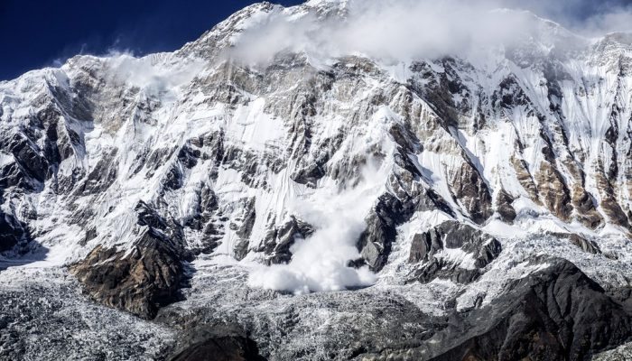
“We frequently heard avalanches but often they were over too quick to capture on camera. Fortunately, this was one of the largest and the camera was at the ready. These avalanches are an important source of mass for the glacier below,” reminisces Emily.
Glaciers accumulate ice throughout the winter months, as snow adds to the glacial column during the cold months. In addition, avalanches deliver additional snow throughout the year.
“I’m not too sure of the scale of the avalanche, it could probably have been a couple of 100 m across. The avalanche occurred early afternoon when the solar radiation was highest and increased melt is likely to have caused the failure,” describes Emily.
Avalanches in the region are not only an important source of mass accumulation for many of the glaciers, they also pose a hazard not only to climbers of these mountains but also further down along the tourist trail up to Annapurna Base Camp, where there is an avalanche risk section of the route.
Imaggeo is the EGU’s online open access geosciences image repository. All geoscientists (and others) can submit their photographs and videos to this repository and, since it is open access, these images can be used for free by scientists for their presentations or publications, by educators and the general public, and some images can even be used freely for commercial purposes. Photographers also retain full rights of use, as Imaggeo images are licensed and distributed by the EGU under a Creative Commons licence. Submit your photos at http://imaggeo.egu.eu/upload/.