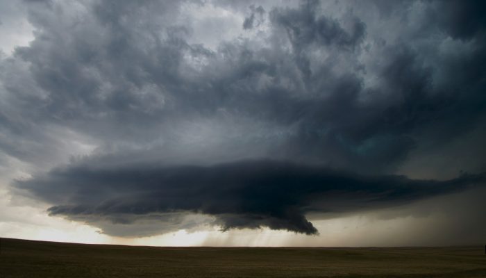
This week’s contribution to Imaggeo on Mondays is a photograph of a mesocyclone – and its rotating wall cloud – photographed by Mareike Schuster, an atmospheric scientist from Freie Universität Berlin, Germany.
The picture was taken in June 2012 near Cheyenne, Wyoming in the United States during a field campaign, ROTATE, led by the Center for Severe Weather Research, based in Boulder, Colorado. ROTATE stands for Radar Observations of Tornadoes and Thunderstorms Experiment. The mission aimed at probing the inner workings of tornadoes to better understand the intensity and variability of low level winds in these vortices. The experiment setup included several mobile Doppler radars (DOWs) that would measure the convective storm from a distance, and also multiple “mobile mesonet” vehicles – vehicles equipped with weather observation instruments- whose passengers would deploy numerous so called “tornado pods” right in the pathway of a tornado. The instruments of the pods might have been destroyed but the data was saved on “armored black boxes” for later analysis.
What are mesocyclones?
A mesocyclone is a cyclone that is embedded within a convective storm – together they form a supercell. The mesocyclone is characterized through ascending air, that in most cases rotates cyclonic. If the mesocyclone has large vertical extent and persists long enough it can be detected by a Doppler radar and appears as a couplet of motion (of the water droplets in the storm towards and away from the radar) in the data.
What is a wall cloud?
The mesocyclone becomes visible through a persistent lowering of the cloud base – the wall cloud – caused by the condensation of updrafting air. The so called wall cloud typically forms beneath the rain free base of a supercell and indicates the area of the strongest updraft. Wall clouds are inflow clouds, local and tend to slope inward. Please note that they are often mixed-up with shelf clouds (not shown), which in turn are outflow clouds that have a larger extent and are associated with a different atmospheric feature. A wall cloud can also form below a thunderstorm if there is no rotation – but if it rotates, then this indicates the existence of a mesocyclone. So it was the case in this picture.
Sometimes, tornadoes form within the mesocyclone of a supercell. The mesocyclone shown here, however, did not.
The motion of the supercell in the shot is towards the observer. All the dark clouds in the photograph basically show the wall cloud. The storm is already very close to the observer. The rest of the thunderstorm, e.g. the cumulonimbus cloud and the typical anvil are so large, they are far above and behind the observer and did not fit on the frame. Everything’s bigger in the U.S. ! 😉
By Mareike Schuster, Institut für Meteorologie, Freie Universität Berlin
The picture was taken with a Nikon D5100 and a Tamron 10-24mm wide angle lense.
Imaggeo is the EGU’s online open access geosciences image repository. All geoscientists (and others) can submit their photographs and videos to this repository and, since it is open access, these images can be used for free by scientists for their presentations or publications, by educators and the general public, and some images can even be used freely for commercial purposes. Photographers also retain full rights of use, as Imaggeo images are licensed and distributed by the EGU under a Creative Commons licence. Submit your photos at http://imaggeo.egu.eu/upload/.