Wild fires: raging walls of flames, capable of burning down swathes of pristine, sometimes protected and ancient, landscapes have been causing havoc around the globe. Managing and controlling them is no easy task; they can unexpectedly change their course with the wind and jump across rivers, roads and man-made fire breaks.
The significant threat they pose, and damage they can cause, to valuable ecosystems worldwide has been recently evidenced by the destruction of 180 million year old forests in Tasmanian; so unique they are a designated United Nations World Heritage wilderness land. Not only that, wildfires can have sever effects on air quality, directly impacting human health, while at the same time contributing hefty amounts of greenhouse gases to the atmosphere. As recently as the end of last year (2015), forest fires in Indonesia were hailed as a ‘crime against humanity‘, after causing over 500,000 cases of acute respiratory tract infections.
This week’s Imaggeo on Mondays photograph highlights an emerging field of research where scientists are developing new methods to try and better understand the past impact of wildfires and how they contributed (or not) to climate change.
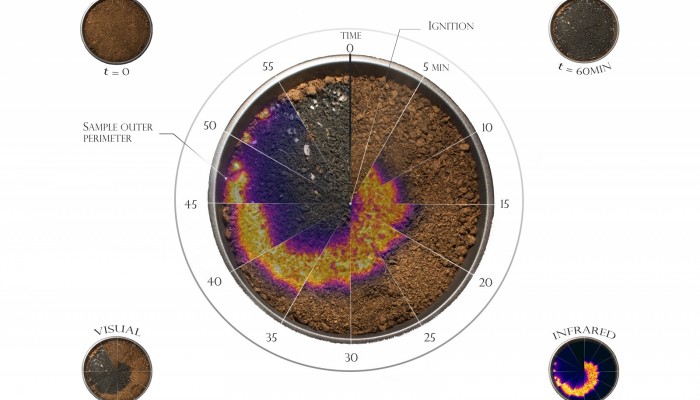
Of his image, Egle Rackauskaite writes: This composite shows a constellation of combined visual and infrared imaging of a smouldering combustion front spreading radially over a thin sample of dry peat. The central watch is created by a series of twelve wedges. Each wedge is extracted from a photo taken every 5 min from an elevated view looking down into the sample during the one-hour lab experiment. The circular peat sample (D=22 cm) was ignited on the centre by an electrical heater. The average radial spread rate was 10 cm/h and the peak temperature 600°C. The top figures show the virgin peat (left) and the final residue (right). The bottom figures show the wedges in visual (left) and infrared (right) imaging. Smouldering combustion is the driving phenomenon of wildfires in peatlands, like those causing haze episodes in southeast Asia and Northeast Europe. These are the largest fires on Earth and an extensive source of greenhouse gases, but poorly studied. Our experiments help to understand this emerging research topic in climate-change mitigation by characterizing the dynamics of ignition, spread and extinction, and also measure the yield of carbon emissions.
If you pre-register for the 2016 General Assembly (Vienna, 17 – 22 April), you can take part in our annual photo competition! From 1 February up until 1 March, every participant pre-registered for the General Assembly can submit up three original photos and one moving image related to the Earth, planetary, and space sciences in competition for free registration to next year’s General Assembly! These can include fantastic field photos, a stunning shot of your favourite thin section, what you’ve captured out on holiday or under the electron microscope – if it’s geoscientific, it fits the bill. Find out more about how to take part at http://imaggeo.egu.eu/photo-contest/information/.

John M. Rehm
Wildfires are more complicated than the Fire Watch post indicates. Let me say, from the outset, that the photographs and infrared displays are effective presentations of what happens to peat, as fire progresses, The analysis does not consider previous conditions to wildfires.
In the Pacific Northwest, I have been in meetings (not conferences) and have read about wildfire causes. One cause is widespread fire suppression by the US Forest Service so that fuel in the understory is more available in successive years. There have been thousands of fire starts in the forests, and many (I don’t know what percentage) fires have occurred because of this condition. Another set-up of a wildfire is a very wet year, where growth of the understory has boomed. This is particularly dangerous in the open range, where wilffires race through low vegetation and grasses. These hazards are common in Texas, and provide frightening TV scenes around Bastrop, Texas.