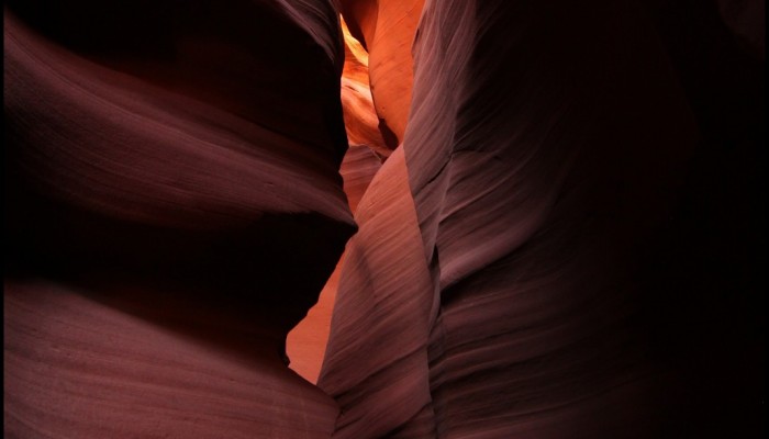
Antelope Canyon, located in Arizona, USA, was formed by erosion of the Navajo Sandstone, primarily due to flash flooding and secondarily due to other sub-aerial processes (think of physical weathering processes such as freeze-thaw weathering exfoliation and salt crystallisation). Rainwater runs into the extensive basin above the slot canyon sections, picking up speed and sand as it rushes into the narrow passageways. Over time the passageways are eroded away, making the corridors deeper and smoothing hard edges in such a way as to form characteristic ‘flowing’ shapes in the rock.
The Navajo Sandstone was deposited in an aeolian (wind-blown) environment composed of large sand dunes: imagine a sea of sand, or an erg, as it is known scientifically, not dissimilar to the present Sarah desert landscape. The exact age of the Navajo Sandstone is controversial, with dated ages ranging from Triassic to early Jurassic, spanning a time period between 250 million years ago to approximately 175 million years ago. The difficulty in determining the exact age of the unit lies in its lack of age diagnostic fossils. The Navajo Sandstone is not alone in this quandary, dating is a common problem in aeolian sediments.
“The picture was taken during a three week Southwest USA road trip in summer 2012. One of the highlights was the visit to Antelope slot canyon, which is located on Navajo land east of Page, Arizona. The Navajo name for Upper Antelope Canyon is Tsé bighánílíní, which means the place where water runs through rocks,” explains Frederik Tack, an atmospheric scientist from the Belgian Institute for Space Aeronomy and author of today’s Imaggeo on Monday’s photograph.
The erosive processes which form the canyon are still ongoing. There is an elevated risk of flash floods, meaning the canyon can only be visited as part of guide tours.
“The canyon was actually quite crowded which made taking this picture challenging, especially as I wanted to capture the peace and solitude of the landscape,” describes Tack.
The effort was worth it: Waved rocks of Antelope slot canyon was one of the EGU’s 2015 Photo Contest finalists!
Imaggeo is the EGU’s online open access geosciences image repository. All geoscientists (and others) can submit their photographs and videos to this repository and, since it is open access, these images can be used for free by scientists for their presentations or publications, by educators and the general public, and some images can even be used freely for commercial purposes. Photographers also retain full rights of use, as Imaggeo images are licensed and distributed by the EGU under a Creative Commons licence. Submit your photos at http://imaggeo.egu.eu/upload/.