One of the world’s most volcanically active regions is the Kamchatka Peninsula in eastern Russia. It is the subduction of the Pacific Plate under the Okhotsk microplate (belonging to the large North America Plate) which drives the volcanic and seismic hazard in this remote area. The surface expression of the subduction zone is the 2100 km long Kuril-Kamchatka volcanic arc: a chain of volcanic islands and mountains which form as a result of the sinking of a tectonic plate beneath another. The arc extends from Hokkaido in Japan, across the Kamchatka Peninsula, through to the Commander Islands (Russia) to the Northwest. It is estimated that the Pacific Plate is moving towards the Okhotsk microplate at a rate of approximately 79mm per year, with variations in speed along the arc.
There are over 100 active volcanoes along the arc. Eruptions began during the late Pleistocene, some 126,000 years ago at a time when mammoths still roamed the vast northern frozen landscapes and the first modern humans walked the Earth.
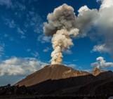
Many of the volcanoes in the region continue to be active today. Amongst them is Karymsky volcano, the focus of this week’s Imaggeo on Mondays image. Towering in excess of 1500 m above sea level (a.s.l), the volcano is composed of layers of hardened lava and the deposits of scorching and fast moving clouds of volcanic debris knows as pyroclastic flows. You can see some careering down the flanks of the volcano in this image of the July 2004 eruption. The eruptive column is the result of a
“strong Vulcanian-type explosion, with the cloud quickly rising more than 1 km above the vent. The final height of the eruption cloud was approximately 3 km and in the image you can clearly see massive ballistic fallout from multiple hot avalanches on the volcanoes slopes,”
explains Alexander Belousov, a Senior Researcher at the Institute of Volcanology and Seismology in Russia and author of this week’s photograph.

USGS map of the Kuril-Kamchatka trench, showing earthquake locations and depth contours on downgoing slab. Credit: USGS, USGS summary of the 2013 Sea of Okhotsk earthquake, via Wikimedia Commons.
If you pre-register for the 2015 General Assembly (Vienna, 12 – 17 April), you can take part in our annual photo competition! From 1 February up until 1 March, every participant pre-registered for the General Assembly can submit up three original photos and one moving image related to the Earth, planetary, and space sciences in competition for free registration to next year’s General Assembly! These can include fantastic field photos, a stunning shot of your favourite thin section, what you’ve captured out on holiday or under the electron microscope – if it’s geoscientific, it fits the bill. Find out more about how to take part at http://imaggeo.egu.eu/photo-contest/information/.