From the rifting of the African continent, to mighty waterfalls in Slovenia, through to a bird’s eye view of the Glarus Thurst in the Alps, images from Imaggeo, the EGU’s open access geosciences image repository, they have given us some stunning views of the geoscience of Planet Earth and beyond. In this post we have curated some of our favourites, including header images from across our social media channels and Immageo on Mondays blog posts of 2014. Of course, these are only a few of the very special images we highlighted in 2014, but take a look at our image repository, Imaggeo, for many other spectacular geo-themed pictures, including the winning images of the 2014 Photo Contest. The competition will be running again this year, so if you’ve got a flare for photography or have managed to capture a unique field work moment, consider uploading your images to Imaggeo and entering the Photo Contest.
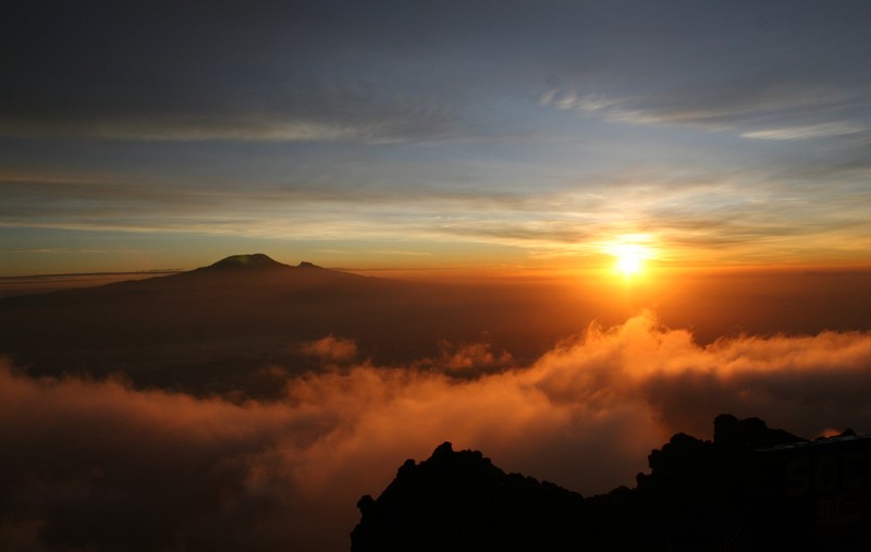
Kilimanjaro from Mount Meru Credit: Alexis Merlaud (distributed via imaggeo.egu.eu)
Plate tectonics in East Africa created Kilimajaro and have also played a role in early human evolution, by shaping the local landscape and the long-term climate, thus modifying the environment of our ancestors. East Africa is the area in the world where most of the hominid fossils have been discovered, including Homo sapiens – the oldest fossil record is 200,000 years old and started to move out from Africa 100,000 years ago!
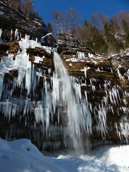
Peričnik waterfall, an amazing sight in Slovenia’s Triglav National Park. (Credit: Cyril Mayaud, distributed by imaggeo.egu.eu)
The picture above shows the lower Peričnik waterfall during winter season. This cascade system is composed of two successive waterfalls that stretch some 16 metres (upper fall) and 52 metres (lower fall) high and is one of the most beautiful natural sights in the Triglav National Park (Slovenia). The cliff is located at the western rim of a U shaped valley and is composed of a very permeable conglomerate rock, which is made up of glacier material that accumulated at the rims of the valley back when the glacier retreated.
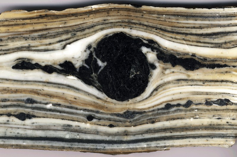
Black Rolling. (Credit: Philippe Leloup via imaggeo.egu.eu)
Polished slab of a mylonitic level of the Ailao Shan Red River shear zone (SE Asia) with an anphibole-rich layer showing left-lateral rolling structure (total width ~20 cm).
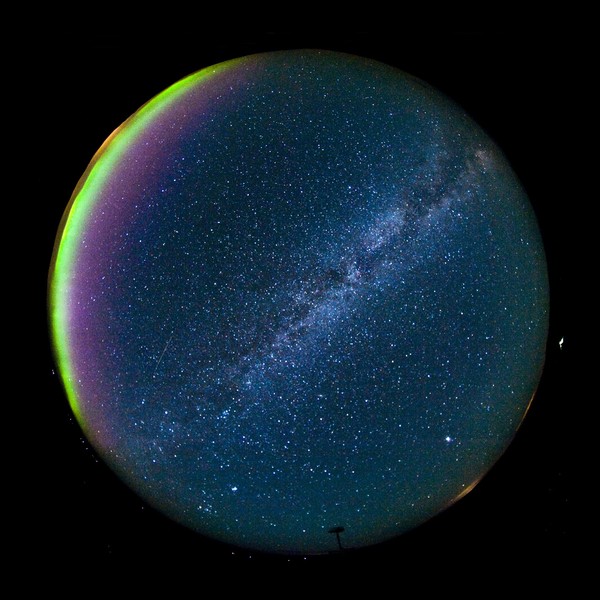
Hessdalen sky & Aurora. (Credit: Bjørn Gitle Hauge distributed via imaggeo.egu.eu)
The night sky over Hessdalen Valley. Together with the radar an all-sky Nikon D700 camera monitors the whole night sky, covering the same area/view as the radar. The camera is equipped with an 8 mm fisheye lens computer controlled by Nikons Camera Control pro2 software, shooting simultaneous pictures with 30 seconds of shutter opening.
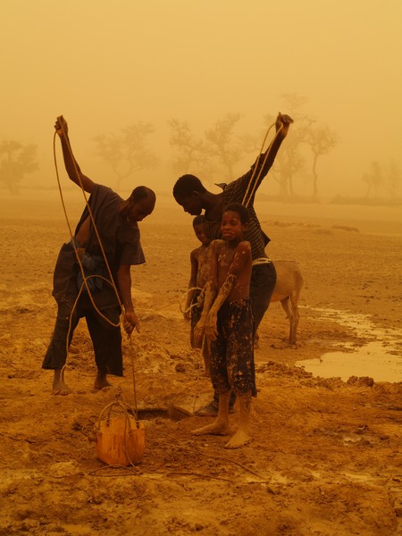
Men and children drawing water for irrigation during a sandstorm. (Credit: Velio Coviello via imaggeo.egu.eu)
One of the winning images of the EGU 2014 Photo Contest, sheds light on the problems associated with conserving soils and water in Western Africa.

Desert fires feeding a convective cloud system over Mono Lake, California. (Credit: Gabriele Stiller distributed via imaggeo.egu.eu)
Wildfires frequently break out in the Californian summer. The grass is dry, the ground parched and a small spark can start a raging fire, but burning can begin even when water is about. When a blaze started beside Mono Lake, what got it going and what it may have started in the sky?
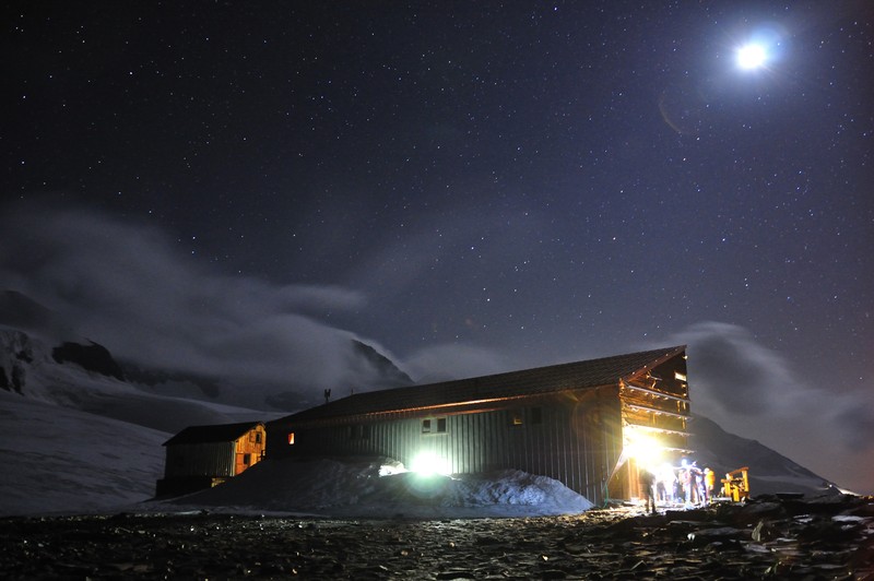
Moonlit glacier. (Credit: Marco Matteucci distributed via imaggeo.egu.eu)
Early morning wake-up at the moonlit Alpine refuge Quintino Sella in the Felik glacier (3585 m). Mount Rosa ridge, Valle d’Aosta, Italy.
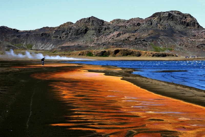
Air, Fire, Earth and Water. (Credit: Sabrina Matzger via imaggeo.egu.eu)
In the summer of 2001, southern Iceland, including the Reykjanes peninsula, was struck by a series of earthquakes, the largest of which was magnitude 6.6. Following the earthquakes, the water levels in Lake Kleifarvatn began to drop; by 2001 the water level had diminished by 4m. A fissure, approximately 400m long and 30cm wide, observed in the vicinity of the lake, was seen to disappear below its waters. It is thought the fissure is responsible for the draining of the lake between 2000 and 2001.
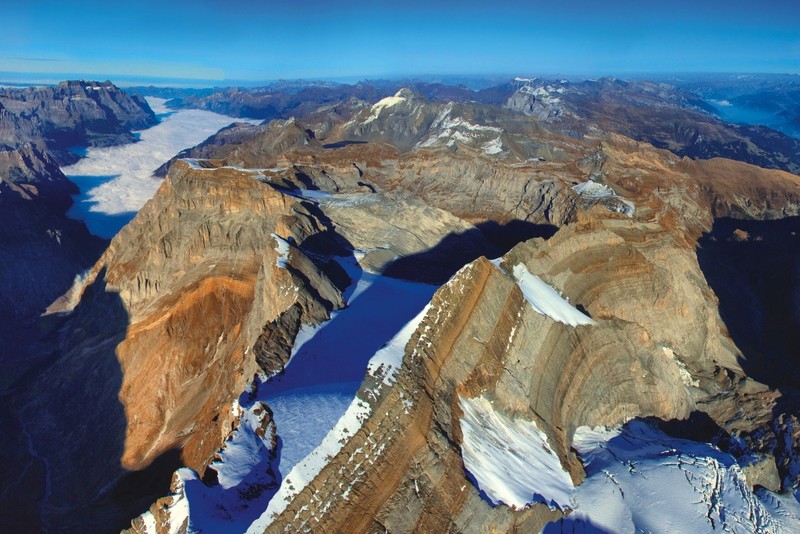
Glarus Alps. (Credit: Kurt Stüwe, via imaggeo.egu.eu)
Undoubtedly, the Alps are one of the best studied mountain ranges in the world. Appreciating their immense beauty and geological wealth can be difficult from the ground, given their vast scale and the inaccessibility of some of their more challenging peaks. Kurt Stüwe, along with alpine photographer Ruedi Homberger, set about changing this by undertaking the ambitious task of photographing the length of the Alps, from Nice to Vienna, in a small aircraft. The result is a compilation of stunning photographs that capture the magnificence of the Alps and contribute to a better understanding of their geological history.
Choosing amongst the 12 beautiful header images we’ve had this year was not easy! Here we highlight three; but in truth, they are all worthy of mention!
Morning Voyage, the April 2014 header image. (Credit: Sierra Pope distributed via imaggeo.egu.eu)
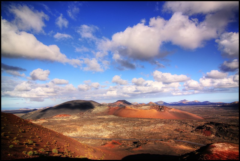
Parque Nacional de Timanfaya – Montañas del Fuego, Lanzarote. Header image of September 2014. (Credit: Frederik Tack distributed via imaggeo.egu.eu)
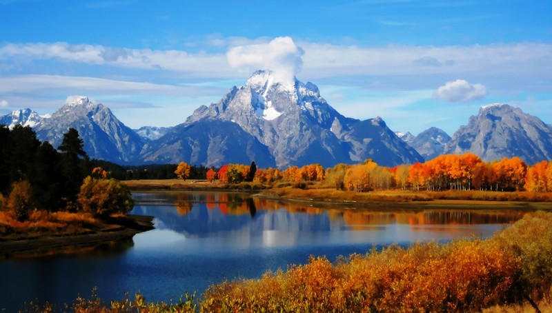
Mount Moran, October 2014. Credit: Josep Miquel Ubalde Bauló distributed via imaggeo.egu.eu)
Mount Moran (12,605 feet (3,842 m)) is a mountain in Grand Teton National Park of western Wyoming, USA. Mount Moran dominates the northern section of the Teton Range rising 6,000 feet (1,800 m) above Jackson Lake.[4] Several active glaciers exist on the mountain with Skillet Glacier plainly visible on the monolithic east face. Like the Middle Teton in the same range, Mount Moran’s face is marked by a distinctive basalt intrusion known as the Black Dike.
As these highlights show, 2014 has spoilt us with an incredible set of images! We look forward to more in 2015. Best wishes from EGU for the new year!
If you pre-register for the 2015 General Assembly (Vienna, 12 – 17 April), you can take part in our annual photo competition! From 1 February up until 1 March, every participant pre-registered for the General Assembly can submit up three original photos and one moving image related to the Earth, planetary, and space sciences in competition for free registration to next year’s General Assembly! These can include fantastic field photos, a stunning shot of your favourite thin section, what you’ve captured out on holiday or under the electron microscope – if it’s geoscientific, it fits the bill. Find out more about how to take part at http://imaggeo.egu.eu/photo-contest/information/.
Pingback: GeoLog | The best of Imaggeo in 2015: in pictures