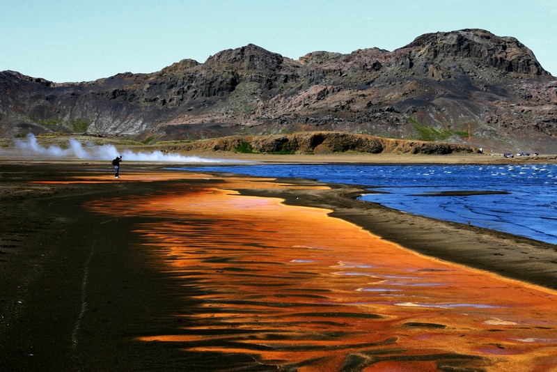
Air, Fire, Earth and Water. (Credit: Sabrina Matzger via imaggeo.egu.eu)
From this week’s Imaggeo on Mondays image it’s easy to see why Iceland is the setting of so many books, films and TV shows, inspiring and inciting writers and film crews alike. The picture was taken on the shores of Lake Kleifarvatn, in Reykjanes peninsula, approximately 30 km to the west of the country’s capital, Reykjavík.
“The Reykjanes peninsula is unique because it marks theboundary between the North American and Eurasian Plates“, explains Sabrina Metzger, who photographed this stunning landscape. Although her PhD thesis focused on the study of plate-boundary deformation in northern Iceland, Sabrina took the photograph on a rare day off in the south of the island, during a “touristic field trip”.
At 9.1 km² and 97m deep, Lake Kleifarvatn is one of the largest lakes on the Reykjanes peninsula, and one of the deepest in the whole country. It varies considerably in size during the year, controlled mostly by changes in groundwater levels, owing to a small catchment area and its lack of any visible surface drainage.
In the summer of 2001, southern Iceland, including the Reykjanes peninsula, was struck by a series of earthquakes, the largest of which was magnitude 6.6. The effects of the ground motion were widespread and affected the local infrastructure, in addition to the landscape. Following the earthquakes, the water levels in Lake Kleifarvatn began to drop; by 2001 the water level had diminished by 4m. A fissure, approximately 400m long and 30cm wide, observed in the vicinity of the lake, was seen to disappear below its waters. It is thought the fissure is responsible for the draining of the lake between 2000 and 2001. At present water levels have returned back to normal, following years of lake sedimentation which have infilled the fissure.
Kleifarvatn and the surrounding area remain a tourist hotspot, not least because of the incredible landscape but added to by the presence of mudspots, stream holes and other frequent geothermal activity. Perhaps the fact that the best-selling Icelandic author Arnaldur Indriðason used the shrinking of the lake caused by the earthquakes in 2001 as a back drop for his thriller The Draining Lake, adds to the appeal of Kleifarvatn.
Imaggeo is the EGU’s open access geosciences image repository. Photos uploaded to Imaggeo can be used by scientists, the press and the public provided the original author is credited. Photographers also retain full rights of use, as Imaggeo images are licensed and distributed by the EGU under a Creative Commons licence. You can submit your photos here.

Wayne
Excellent article! We are linking to this particularly great article on our website. Keep up the good writing.