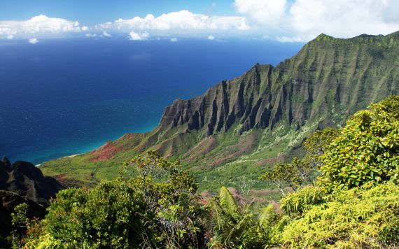
“Kalalau Valley” by Martin Mergili, taken from Kalalau Lookout on the island of Kauai, distributed by the European Geosciences Union under a Creative Commons License.
At over 5 million years old, the island of Kauai is the oldest island in the Hawaiian Achipelago. Hawaii, Maui and Oahu are all younger and lie further to the southeast. This island chronology is no coincidence – the Archipelago formed as a result of intra-plate volcanic activity.
Intra-plate volcanism occurs where an upwelling magma plume or ‘hot spot’ lies beneath a continental plate. In this case, the Pacific Plate has moved over a hot spot in the northwestern direction, so that the younger and more active islands are located in the southeast, and the older islands are further north. As the plate passes further from the hotspot, the crust cools, becoming less buoyant and causing the oldest islands in the chain to sink and form atolls when fully submerged.
Volcanic has ceased on Kauai and now erosive forces are those that shape the island, resulting in deep gullies and canyons cut into the highlands. In the north and northwest of Kauai the roaring waves of the Pacific Ocean hit the island after travelling for thousands of kilometres undisturbed. These waves meet a steep and rugged coastline with swells that can reach 10 m high on the Na Pali Coast. Running water has cut spectacular valleys into these cliffs, forming the Nualolo and Awaawapuhi, and Kalalau (above) Valleys. During the summer, carbonate sands fringe the island – you can just about see them here, but they are washed away by heavy wave action in the winter months.
This view of the Kalalau Valley was captured by Martin Mergili (Geologist from BOKU, University of Natural Resources and Life Sciences, and keen photographer), who explains that he took “this photo on a holiday trip to Hawaii in August 2010 (as far as a geoscientist can spend a “real” holiday in Hawaii). The viewpoint is called Kalalau Lookout, located in the humid highlands of Kauai, close to the misty Alakai Swamps and Mount Waialeale, one of the wettest places on Earth”.
Imaggeo is the EGU’s online open access geosciences image repository. All geoscientists (and others) can submit their images to this repository and since it is open access, these photos can be used by scientists for their presentations or publications as well as by the press and public for educational purposes and otherwise. If you submit your images to Imaggeo, you retain full rights of use, since they are licensed and distributed by the EGU under a Creative Commons licence.
