As mountain glaciers melt and recede, they often leave behind large glacial lake that are contained by the glaciers’ old terminal moraines. These glacial lakes are found throughout the world and can pose a significant flood hazard to downstream communities and infrastructure.
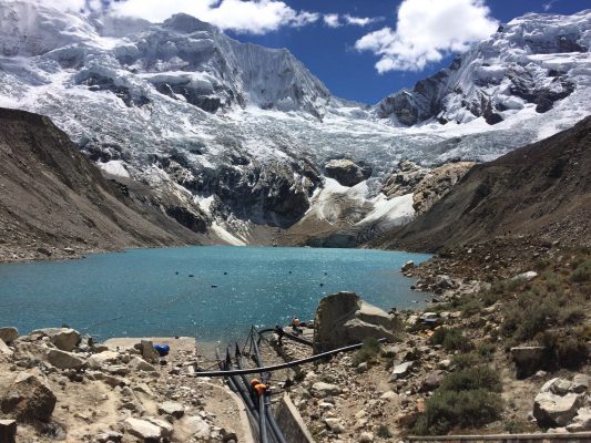
The image of this week focuses on Lake Palcacocha, a large glacial lake located in Peru’s Cordillera Blanca at an elevation of 4,562 m. It is one of Peru’s most dangerous glacial lakes because it threats to flood the inhabited valley downstream.
More than 75 years of flood hazard
In 1941, an avalanche entered the glacial lake, causing a tsunami-like wave that overtopped and eroded its terminal moraine, and ultimately triggered a glacial lake outburst flood. The flood traveled down the valley and killed an estimated 1,800-6,000 people in the city of Huaraz (see map below). The flood drained the volume of the lake from 10-12 million m³ to just 0.5 million m³.
![A map showing the location of Lake Palcacocha and the city of Huaraz below [Credit: fig 1 from Somos-Valenzuela et al., (2016)] LINK: http://www.hydrol-earth-syst-sci.net/20/2519/2016/](https://blogs.egu.eu/divisions/cr/files/2016/09/Map-of-Palcacocha-and-Huaraz.jpg)
A map showing the location of Lake Palcacocha and the city of Huaraz [Credit: fig 1 from Somos-Valenzuela et al., (2016)]
The 1941 flood drained the volume of the lake from 10-12 million m³ to just 0.5 million m³
In 1974, to prevent this from happening again, a drainage structure was built that lowered the level of the lake by 8 m. However, over the years as the glacier continued to recede, the glacial lake continued to grow. In 2011, siphons were also installed (see our image this week) within the drainage structure to lower the lake by an additional 3-5 m.
Visiting the hazardous lake
Despite these major efforts to reduce the flood hazard, the lake is now over 73 m deep with a volume exceeding 17 million m³. As part of the Foro Internacional de Glaciares y Ecosistemas de Montaña, a weeklong conference bringing together international experts on topics related to the social, ecological, hydrological, and hazard studies associated with mountain ecosystems, INAIGEM (Instituto Nacional de Investigación en Glaciares y Ecosistemas de Montaña) organized a field expedition that brought ~30 participants to visit Lake Palcacocha. The view of the lake, with its two 6,000+ m peaks behind it, was absolutely stunning. Unfortunately, the glaciers on these peaks are the very things that threaten the lake’s safety, as an avalanche entering the lake could cause another glacial lake outburst flood like the 1941 event – a possibility Peru is very well aware of.
Modelling the glacial lake outburst flood
In response to this threat, a team from the University of Texas at Austin (Daene McKinney, Marcelo Somos-Valenzuela, Rachel Chisolm, and Denny Rivas) has been working closely with Peruvian organizations (INAIGEM and the Glaciology Unit) to model the potential flood from Lake Palcacocha. Hydraulic models were used to investigate the downstream impact, produce preliminary hazard maps, and quantify the amount that the lake should be lowered in order to reduce the hazard of the lake to a safe level. The study of Somos-Valenzuela et al. (2016) found that lowering the level of the lake by 30 m would reduce the total affected area by 30% and, more importantly, would reduce the intensity of the flood (a combination of the water depth and velocity) for most of the city from high to low thereby making the lake much safer.
![Overview of the avalanche, lake, and terminal moraine (left) and the potential inundation downstream based on the current level of the lake (right) performed by the University of Texas at Austin. [Credit: fig 2 and 10 from Somos-Valenzuela et al., (2016)] LINK: http://www.hydrol-earth-syst-sci.net/20/2519/2016/ .](https://blogs.egu.eu/divisions/cr/files/2016/09/Palcacocha-Flood-Model-Results.jpg)
Overview of the avalanche, lake, and terminal moraine (left) and the potential inundation downstream based on the current level of the lake (right) performed by the University of Texas at Austin. [Credit: fig 2 (left) and 10 (right) from Somos-Valenzuela et al., (2016)]
A hopeful future
The good news for Peru is they have extensive experience lowering the level of their lakes and safely reducing the hazards. Since the Government of Peru established a Glaciology Unit in 1951, Peru has successfully lowered the level over 30 glacial lakes that were considered to be hazardous. Additionally, the citizens of Huaraz are well aware of the hazardous lakes situated above their city and want them to be lowered as well. Given Peru’s track record, hopefully their concerns will be alleviated soon.
Further Reading
- Portocarrero, C. A. R. (2014). The glacial lake handbook—reducing risk from dangerous glacial lakes in the Cordillera Blanca, Peru. USAID technical report, p 80.
- Somos-Valenzuela, M.A., Chisolm, R.E., Rivas, D.S., Portocarrero, C., and McKinney, D. (2016). Modeling a glacial lake outburst flood process chain: the case of Lake Palcacocha and Huaraz, Peru, Hydrol. Earth Syst. Sci, 20:2519-2543, doi:10.5194/hess-20-2519-2016.
- Previous blog post about Imja Lake, which can potentially trigger a glacial lake outburst flood in Nepal.
Edited by Sophie Berger and Emma Smith

Pingback: Cryospheric Sciences | Did you know that glacier mass loss affects water resources?
Pingback: Cryospheric Sciences | Women of Cryo III: Women monitoring the Peruvian glaciers
Pingback: Znikające lodowce tropikalne – dlaczego ich żałujemy? - naukaoklimacie.pl
Pingback: Znikające tropikalne lodowce – dlaczego ich żałujemy? | Glacjoblogia
Pingback: GeoLog | Glacial lake outburst floods: What we know about this destructive ice hazard
Pingback: Study: 15 million people live under threat of glacial floods - NewsFinale
Pingback: Study: 15 million people live under threat of glacial floods - the little Blue Book
Pingback: Study: 15 million people live under threat of glacial floods – CFHits
Pingback: 15 million people live under threat of glacial floods #million #people #live #threat #glacial #floods #englishheadline
Pingback: Millions Live Under Threat of Deadly Floods as Glaciers Melt - RIO SATELLITE
Pingback: Study: 15 million people live under threat of glacial floods - Alex Walia world updates
Pingback: 15 Million People Live Under Threat of Sudden, Deadly Flooding as More Glaciers Melt - Daily Briefs
Pingback: Buzullar Erirken Milyonlarca Ölümcül Sel Tehdidi Altında Yaşıyor - Web Haberler
Pingback: Hundreds of thousands Stay Below Risk of Lethal Floods as Glaciers Soften - Informations Hub
Pingback: Millions Live Under Threat of Deadly Floods as Glaciers Melt – Battle Mag News
Pingback: Millions Live Under Threat of Deadly Floods as Glaciers Melt – DailyTechTop
Pingback: Millions Live Under Threat of Deadly Floods as Glaciers Melt | Insider Wave
Pingback: Millions Live Under Threat of Deadly Floods as Glaciers Melt - Trending News | Latest News
Pingback: Millions live under the threat of deadly floods as glaciers melt – Newswesty
Pingback: Millions Live Under Threat of Deadly Floods as Glaciers Melt | Trend Supplier
Pingback: Millions live under the threat of deadly floods as glaciers melt - Bts Booth
Pingback: 15 miljoen mensen leven onder de dreiging van plotselinge, dodelijke overstromingen naarmate meer gletsjers smelten – 1NEWS
Pingback: Buzullar Erirken Milyonlarca Ölümcül Sel Tehdidi Altında Yaşıyor - Mersin Flash Haber
Pingback: Examine: 15 million individuals reside beneath menace of glacial floods - Cleveland News Today
Pingback: Millions Live Under Threat of Deadly Floods as Glaciers Melt - World News Paper Now
Pingback: Study: 15 Million People Live Under Threat of Glacial Floods - US Quick Updates
Pingback: Hundreds of thousands Reside Beneath Risk of Lethal Floods as Glaciers Soften - Upper Times
Pingback: 15 Million People Live Under Threat of Sudden, Deadly Flooding as More Glaciers Melt - Globe Echo
Pingback: Millions Live Under Threat of Deadly Floods as Glaciers Melt - News Thoughts
Pingback: Millions Live Under Threat of Deadly Floods as Glaciers Melt - NewsNTips
Pingback: 15 Million People Live Under Threat of Sudden, Deadly Flooding as More Glaciers Melt - Business News Media
Pingback: 15 Million People Live Under Threat of Sudden, Deadly Flooding as More Glaciers Melt – NewsDeal
Pingback: 15 Million People Live Under Threat of Glacial Floods - Overseas Updates
Pingback: Millones viven bajo la amenaza de inundaciones mortales a medida que los glaciares se derriten – Radio Sin Fronteras
Pingback: Examine: 15 Million Folks Stay Below Menace of Glacial Floods - Bloging Express
Pingback: 15 Million People Live Under Threat of Sudden, Deadly Flooding as More Glaciers Melt – Open News Market
Pingback: Millions Live Under Threat of Deadly Floods as Glaciers Melt – XIO HEALTH
Pingback: 15 Million People Live Under Threat of Sudden, Deadly Flooding as More Glaciers Melt | The News Lynx
Pingback: 15 Million People Live Under Threat of Sudden, Deadly Flooding as More Glaciers Melt | The Gay Land
Pingback: 15 Million People Live Under Threat of Sudden, Deadly Flooding as More Glaciers Melt - The Shared Links – The News And Times
Pingback: 15 Million People Live Under Threat of Sudden, Deadly Flooding as More Glaciers Melt | The FBI Reform - fbireform.org
Pingback: Tens of millions Reside Underneath Risk of Lethal Floods as Glaciers Soften – CenterNews24.com
Pingback: Buzullar Erirken Milyonlarca Ölümcül Sel Tehdidi Altında Yaşıyor - Kıvırcık